Lavegahau
| Lavegahau | ||
|---|---|---|
|
|
||
| Coordinates | 13 ° 19 ′ S , 176 ° 11 ′ W | |
| Basic data | ||
| Country | France | |
| Wallis and Futuna | ||
| kingdom | Uvea | |
| ISO 3166-2 | WF | |
| District | Mu'a | |
| Residents | 342 (2013) | |
|
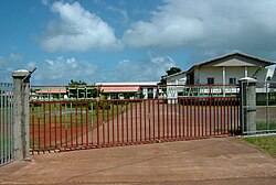
Agricultural vocational school "Vaimoana" in Lavegahau
|
||
Lavegahau is a village in the Muʻa district in the Kingdom of Uvea , which belongs to France as part of the French overseas territory of Wallis and Futuna .
location
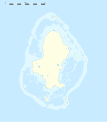
Lavegahau is located on the east coast of the Muʻa district in the southeast of the island of Uvea , which belongs to the Wallis Islands . The village is located between Tepa in the south and Ha'afuasia in the north. In the western part of Lavegahau there is a chapel and the agricultural vocational school "Vaimoana". A sparsely populated settlement area extends further west of the village , which extends into the center of the island to a larger road. There is a bar and the Lac Lanumaha ( German Lanumaha-See ).
population
As in the rest of Wallis and Futuna, the population is decreasing. But weaker than in other parts:
| Lavegahau: Population from 1996 to 2013 | ||||
|---|---|---|---|---|
| year | Residents | |||
| 1996 | 331 |
|||
| 2003 | 379 |
|||
| 2008 | 359 |
|||
| 2013 | 342 | |||
| Data source: INSEE | ||||
Individual evidence
- ↑ Populations légales des îles Wallis et Futuna en 2013. Institut national de la statistique et des études économiques (INSEE), November 21, 2013, accessed on December 1, 2017 (French).

