
Le Gouray
| Le Gouray | ||
|---|---|---|
.svg)
|
|
|
| local community | Le Mené | |
| region | Brittany | |
| Department | Cotes-d'Armor | |
| Arrondissement | Dinan | |
| Coordinates | 48 ° 20 ′ N , 2 ° 29 ′ W | |
| Post Code | 22330 | |
| Former INSEE code | 22066 | |
| Incorporation | January 1, 2016 | |
| status | Commune déléguée | |

Le Gouray ( Gallo : Le Gorae , Breton Gorre ) is a town and commune Déléguée in the French commune of Le Mené with 1,292 inhabitants (at January 1, 2017) in Côtes-d'Armor in the region of Brittany . The inhabitants are called Gourayens / Gourayennes .
geography
Le Gouray is located about 29 kilometers southeast of Saint-Brieuc in the eastern half of the Côtes-d'Armor department.
history
The first traces of settlement such as the Allée couverte des Meurtiaux date from the Neolithic. Further excavations brought remains from the Celtic and Gallo-Roman times to light.
The parish arose in the early Middle Ages. In 1205 the place was first mentioned by name as Gorre in a church document. In addition, the district of La Motte-du-Parc was the seat of a lordship in the Middle Ages. Various epidemics haunted the community until modern times. In the 13th century there was a leprosy station in Le Gouray. On October 24, 1823, the Saint-Mirel settlement moved from Le Gouray to Collinée. At the same time, the Bransart settlement moved to Saint-Jacut-du-Mené. And on August 10, 1849, the municipality ceded various areas in the south to the municipality of Saint-Jacut-du-Mené. The municipality belonged to the Broons district from 1793 to 1801 and was the capital of the canton of Le Gourray. From 1801 to 1926 it was part of the Loudéac arrondissement and has since been part of the Dinan arrondissement. And from 1801 to 2015 it was a municipality in the canton of Collinée .
With effect from January 1, 2016, the new municipality of Le Mené , to which Le Gouray belongs , was created from the merger of all seven municipalities of the Communauté de communes du Mené . The municipality of Le Gouray belonged to the Arrondissement of Dinan and the canton of Plénée-Jugon .
Population development
The number of residents increased slightly between 1793 and 1836 (1793–1836: + 10.5%). This was followed by the first wave of emigration as a result of the increasing mechanization of agriculture (1836–1856: −17.2%). Until the turn of the century around 1900, the population remained at roughly the same level. A second wave of emigration began as early as 1900, which intensified as a result of the numerous dead and the flu wave of 1918. The strong rural exodus continued until around 1980 (1901–1982: −51.1%). After the turn of the millennium, there was significant growth (1999–2012: +34.3%).
| year | 1793 | 1800 | 1806 | 1821 | 1831 | 1836 | 1841 | 1846 | 1851 | 1856 | 1861 | 1866 | 1872 | 1876 | 1881 | 1886 | 1891 | 1896 |
|---|---|---|---|---|---|---|---|---|---|---|---|---|---|---|---|---|---|---|
| Residents | 2.120 | 2.117 | 2,097 | 2,179 | 2,301 | 2,342 | 2,219 | 2,252 | 2,032 | 1,940 | 2.012 | 1,942 | 1,942 | 2,033 | 1.993 | 2.015 | 1,954 | 1.965 |
| year | 1901 | 1906 | 1911 | 1921 | 1926 | 1931 | 1936 | 1946 | 1954 | 1962 | 1968 | 1975 | 1982 | 1990 | 1999 | 2006 | 2012 | 2013 |
| Residents | 1,906 | 1,784 | 1,740 | 1,626 | 1,558 | 1,433 | 1,346 | 1,237 | 1,143 | 1.108 | 1,068 | 988 | 932 | 944 | 939 | 1,072 | 1,261 | 1,263 |
Source: Cassini and INSEE from 1962
Attractions
- Château de la Motte Basse castle
- Saint-Étienne village church (built in 1854)
- 12th century Saint-Roch chapel (restored in the 17th century)
- La Motte-Basse chapel from 1759
- Calvary of La Motte-Basse
- numerous crosses and wayside crosses from the 17th and 18th centuries
- several mansions: Manoir du Vau-Raulet , Manoir de la Motte du Parc (15th century), Manoir des Murs (17th century) and Manoir de Quilloury (16th century)
- old houses in the village center (built 1777) and Truet (built 1573)
- Le Gros-Chêne estate from 1840
- several mills
- 18th century thatched house in Le Limbé
- Lavoir (wash house) in Noë-Perghien
- Allée couverte from the Neolithic in L'Épine
- Pont de Planchettes railway bridge (inaugurated in 1924)
- Memorial to the Fallen

Château de la Motte Basse

former town hall (Mairie) of Le Gouray

Saint-Etienne village church
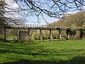
former railway bridge

Cross at the Château de la Motte Basse


literature
- Le Patrimoine des Communes des Côtes-d'Armor. Flohic Editions, Volume 1, Paris 1998, ISBN 2-84234-017-5 , pp. 186-190.
Web links
Individual evidence
- ↑ Description of the sights (French) ( Memento of the original from September 24, 2016 in the Internet Archive ) Info: The archive link was inserted automatically and has not yet been checked. Please check the original and archive link according to the instructions and then remove this notice.
- ↑ Memorial to the Fallen