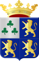
Leeuwarderadeel
 flag |
 coat of arms |
| province |
|
| local community |
|
|
Area - land - water |
41.46 km 2 40.89 km 2 0.57 km 2 |
| Residents | 10,089 (Dec. 31, 2017) |
| Coordinates | 53 ° 15 ' N , 5 ° 45' E |
| prefix | 0518, 058 |
| Postcodes | 9051-9057 9071-9072 |
Leeuwarderadeel ( ) ( West Frisian Ljouwerteradiel ) is a former municipality in the Dutch province of Friesland . On January 1, 2018, it was incorporated with part of Littenseradiel in Leeuwarden . Leeuwarderadeel had 10,089 inhabitants at the time of the dissolution.
The administrative center is Stiens, the other places in the municipality are: Bartlehiem (partly), Britsum, Cornjum, Finkum, Hijum, Jelsum and Oude Leije.
politics
Distribution of seats in the municipal council
| Political party | Seats | |||
|---|---|---|---|---|
| 2002 | 2006 | 2010 | 2014 | |
| PvdA | 3 | 4th | 4th | 4th |
| CDA | 3 | 3 | 3 | 4th |
| Community affairs Leeuwarderadeel | 6th | 5 | 3 | 3 |
| FNP | 2 | 2 | 3 | 2 |
| VVD | 1 | 1 | 2 | 2 |
| total | 15th | 15th | 15th | 15th |
Web links
Commons : Leeuwarderadeel - Collection of images, videos and audio files
Individual evidence
- ↑ a b Bevolkingsontwikkeling; regio per maand Centraal Bureau voor de Statistiek , accessed on June 17, 2018 (Dutch)
- ↑ Allocation of seats in the municipal council: 2002 ( Memento of the original dated June 15, 2018 in the Internet Archive ) Info: The archive link was inserted automatically and has not yet been checked. Please check the original and archive link according to the instructions and then remove this notice. 2006 2010 2014 , accessed June 17, 2018 (Dutch)
