
Lefkos
|
Lefkos Λευκός |
|||
|---|---|---|---|
|
|||
| Basic data | |||
| Country |
|
||
| region | South Aegean | ||
| Regional district | Karpathos and Kasos | ||
| local community | Karpathos | ||
| Parish | Karpathos | ||
| Local community | Mesochori | ||
| status | settlement | ||
| Geographic coordinates | 35 ° 35 ′ N , 27 ° 4 ′ E | ||
| Residents | 146 (2011, here the sum of the two districts Lefkos (57 inhabitants) and Kato Lefkos (89 inhabitants)) | ||
| LAU-1 code no. | 62010106-02 / 03 | ||
| Post Code | 85700 | ||
| Telephone code | 22450-2 | ||

Lefkos ( Greek Λευκός ( m. Sg. ), White ') is a hamlet with a coastal settlement of the local community Mesochori in the far west of the Greek island of Karpathos . The former outlying settlement Mesochoris today consists of the two settlements Lefkós and Káto Lefkós . Although Greek authorities recognize them as independent places, in everyday parlance they are collectively referred to as Lefkós ; the coastal settlement can also be found in the offerings of tour operators.
location

Lefkos is almost in the middle of the west coast of Karpathos. The settlements are located about 5 kilometers southwest of Mesochori and 16 kilometers northwest of the city of Karpathos . The actual Lefkós , also called Áno Lefkós ( Eng . 'Upper Lefkos') or Ágios Geórgios , is located at the junction from the west coast road to Káto Lefkós . The settlement of Káto Lefkós ( Eng . 'Lower Lefkos') is located about 2.5 kilometers southwest directly by the sea.
history
At the site of today's Káto Lefkós there was a wealthy early Byzantine port town in the fifth century, which had existed since the late Roman period and was probably abandoned because of Saracen invasions in the seventh century.
The geographical location made it possible to control the west coast of Karpathos as well as the coastal plain to the east, which is bordered inland by an edge of terrain more than 20 meters high. The city developed on three ports facing south, west and northwest, as well as on the peninsulas in between. In the densely populated city, commercial facilities and storage rooms with pithos-like storage vessels were detected during small exploratory excavations through the 4th Ephoria for Byzantine and Post-Byzantine Antiquities in 2000 and 2010. Two early Christian basilicas in the vicinity of Káto Lefkós have so far been archaeologically examined, others are known in the vicinity. The archaeological finds recovered so far as well as the number of basilicas suggest a prosperous city in the early Byzantine period. Around 410 AD the Carpathian merchant fleet ran regularly with grain from Alexandria to Constantinople . Due to several preserved cisterns on the plateau of the nearby island of Sokastro , the island is now considered a naval base.
20th century
The area was not repopulated until the end of the 20th century. Káto Lefkós developed into a major tourist destination on the west coast of Karpathos. About 9% of the island's guest beds are in the village and the surrounding area.
A larger piece of land along the coast was purchased years ago by the Greek archaeological service to protect it from tourist development and to preserve the undisturbed location of the early Byzantine port city for further excavations.
Population development
The smaller inland district of Lefkós was created in the last quarter of the 20th century and was officially recognized as a settlement in 1981, while Káto Lefkós was officially recognized as a settlement in 1991. In fact, both settlements are considered together.
| Surname | LAU code | 1981 | 1991 | 2001 | 2011 |
|---|---|---|---|---|---|
| Lefkos (Agios Georgios) | 81120603 | 65 | 25th | 28 | 57 |
| Kato Lefkos | 81120602 | 37 | 81 | 89 | |
| Lefkos total | 65 | 62 | 109 | 146 |
Attractions
So far no systematic archaeological research has been carried out in the vicinity of Lefkos, but several architectural monuments are known from the late Roman to the early Byzantine period. To protect the antiquities, the Lefkos region was widely designated as an archaeological site in 1999, including the island of Sokastro.
- On the beach by the landing stage are the remains of an apse of the early Christian basilica Panagia Gialochorafitissas ; probably built in the 5th century and burnt down by pirates around 300 years later. Researchers only discovered the mosaic floor of this former church in the 1980s, which is still mostly completely covered with sand.
- There is a former Roman cistern with a ceiling made of huge ashlar stones, slightly elevated around 500 m from the stand . Steps lead below the surface into a high room supported by 13 columns. The original use of this space was not completely clear for a long time (tomb, fortress, storage room), but archaeologists today believe that it is a cistern from Roman times.
- There is a large cave slightly elevated around 500 m from the beach . This cave was created during the Ice Age , when masses of water washed under the rock plateau. The cave was once divided into several rooms with stone walls. Archaeological finds and wall remains suggest that this cave was used by the inhabitants for thousands of years until a few decades ago.
- At the hamlet of Agios Georigis (around 3 km west of the coast towards Kali Limni ) is the chapel of Agios Géorgios tou Lefkoú . It is the only undestroyed cross-domed church on Karpathos. With the exception of the head of Saint Dimitrios, the frescoes inside, around 800 years old, are barely recognizable. A small bell tower and a fountain were later built next to the chapel.
- About 15 minutes by boat north of Lefkos is the rocky, uninhabited island of Sokastro . In addition to a small beach, foundations, columns and cisterns from the Byzantine era and the time of the Crusaders are visible there.
beaches

Lefkos is known for its variety of beaches.
- (1) Potali pebble beach : Located at the southern end of the coast of Lefkos, between the settlements of Lefkos (Agios Georgios) and Kato Lefkos.
- (2) Gialou Chorafi sandy beach (German: Steinacker): Also called Limani , as the small fishing port is located in this central bay. The bay is protected by moles, the water is shallow, and tamarisks provide some shade.
- (3) Limani Panagia Bay : Stretches to the rear of the harbor front, calm water and fine sand.
- (4) Frangolimionas Bay : Wide sandy beach with stronger waves.
- (5) Perdikas Potami Bay : Elongated bay, mostly rocky with small sandy beaches in between. Stretches to the strait to the uninhabited island of Sokastro .
Photo gallery
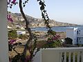
Potali Bay in the south of Lefkós
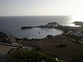
Lefkos Bay

Agios Georgios chapel

Roman cistern at Lefkos


literature
- Antje Schwab, Gunther Schwab: Karpathos . Verlag Michael Müller, Cologne 2010, ISBN 978-3-89953-537-2 .
Individual evidence
- ↑ Results of the 2011 census, Greek Statistical Office (ΕΛ.ΣΤΑΤ) ( Memento from June 27, 2015 in the Internet Archive ) (Excel document, 2.6 MB)
- ↑ LSP: The Leukos Survey Project at Queens College, City University of New York ; The Leukos Survey Project 2011 at the Canadian Institute in Greece (English); Karpathos - Leukos, Archeology in Greece Online by EfA , BSA (French); Dominique Mulliez: Karpathos, Leukos Survey . In: Cambridge University Press (Ed.): Archaeological Reports . tape 56 , 2010, p. 169 , doi : 10.1017 / S0570608410000347 .
- ↑ Επενδυτικός Οδηγός Καρπάθου, Κέντρο Υποδοχής Επενδυτών (Κ.Υ.Ε), Νομού Δωδ / νήσου p. 12 (PDF; 1.0 MB)
- ↑ Αρχαιολογικός χώρος Λευκού Καρπάθου, Διαρκής Κατάλογος των Αρχαιολογικών Χώρων και Μνημείων της Ελλάδος (Archaeological Site of Lefkos Karpathos, list of sites and monuments of Greece), Ministry of Culture and Tourism (Greek)
- ↑ Ερείπια παλαιοχριστιανικής βασιλικής - Λευκός, South Aegean Region (Greek)
- ↑ Τάφοι - Λευκός, θέση Ριά, South Aegean Region (Greek)
- ↑ Άγιος Γεώργιος - Λευκός, South Aegean Region (Greek)