
Lihou Reef National Nature Reserve
| Lihou Reef and Cays | ||
|---|---|---|
 |
||
| Waters | Coral sea | |
| archipelago | Coral Sea Islands | |
| Geographical location | 17 ° 25 ′ S , 151 ° 40 ′ E | |
|
||
| Number of islands | 18th | |
| Main island | Lorna Cay | |
| length | 100 km | |
| width | 30 km | |
| Land area | 1.03 km² | |
| total area | 2 529 km² | |
| Highest elevation | 6 m | |
| Residents | uninhabited | |
 |
||

Lihou Reef National Nature Reserve is a 8,440 km² marine reserve in Australia in the Coral Sea . The eponymous atoll Lihou Reef should not be confused with the island of Lihou . It is located off the east coast of Australia about 700 km from Cairns in Queensland . Together with the Coringa-Herald National Nature Reserve 100 km away , it forms the larger Coral Sea Reserves Ramsar Site with an area of 17,290 km, which was established on August 16, 2002. It is a wetland of international importance according to the Ramsar Convention and one of the largest lagoons in the world.
history
Now known as Lihou Reef and Cays , the atoll was discovered by Lieutenant John Lihou of the Royal Navy on February 23, 1823. Lihou, who was a ship master on the brig HMS Zenobia , was en route from Manila to South America . After a dangerous passage through the Great Barrier Reef , it left this through an opening in the Murray Islands . On the further journey through the Coral Sea , the atoll Lihou Reef and Cays , 1155 km as the crow flies from the Murray Islands, was sighted.
geography
The Lihou Reef is the second largest atoll in the Coral Sea , according to to New Caledonia belonging Chesterfield Islands (here the even larger submarine is Lansdowne Bank not included). It is U-shaped, with an opening in the southwest. The size of the lagoon measures 100 by 30 km, with an area of 2,529 km², and makes this atoll one of the largest in the world, although the total land area of all islands on the fringing reef ( Cays ) is barely more than one square kilometer. The lagoon is about 60 m deep. The marine reserve includes 18 cays, 9 each in the Northern Rim and 9 in the Southern Rim , ranging in size from 0.5 to 16.8 hectares .
|
|
The cays with vegetation are marked in green in the table.
Turtle Islet is 6 m above sea level and Observatory Cay is 2 m above sea level. There is an automated weather station on Turtle Islet .
In the northeast of Anne Cay , the Herald Passage can be used to access the lagoon.
Flora and fauna
The flora and fauna of this sea area is different from the Great Barrier Reef , which lies to the west. There are fish, hermit crabs , starfish , various algae, corals, sea urchins and sea cucumbers . The protected green sea turtle, dolphins and whales are also found.
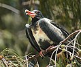
Bird species such as red-footed booby , ariel frigate and red-tailed tropical bird can be found in this marine reserve.

Green turtle

Dolphin
Ariel frigate bird


Web links
- Location map of the former marine reserve (PDF) Licklick Cay (northeast) is missing
- environment.gov.au (PDF; 435 kB): Coral Sea, National Nature Reserve (information brochure) (English)
- oceandots.com ( Memento of December 23, 2010 in the Internet Archive ): Pictures of the reserve
Individual evidence
- ^ The Annotated Ramsar List: Australia . The Ramsar Convention on Wetlands. January 4, 2000. Retrieved March 29, 2010.
- ^ Source: Hydrographic Service - Royal Australian Navy. (MA BOLGER. Lieutenant Commander RAN for DIRECTOR HYDROGRAPHIC OFFICE. July 19, 1985)