
Lilla Edet
| Lilla Edet | ||||||
|
||||||
| State : | Sweden | |||||
| Province (län): | Västra Götalands län | |||||
| Historical provinces (landskap): |
Västergötland Bohuslän |
|||||
| Municipality : | Lilla Edet | |||||
| Coordinates : | 58 ° 8 ' N , 12 ° 8' E | |||||
| SCB code : | 4924 | |||||
| Status: | Crime scene | |||||
| Residents : | 3772 (December 31, 2015) | |||||
| Area : | 3.11 km² | |||||
| Population density : | 1213 inhabitants / km² | |||||
| Lilla Edet västra | ||||||
|---|---|---|---|---|---|---|
| Coordinates : | 58 ° 8 ' N , 12 ° 6' E | |||||
| SCB code : | 4490 | |||||
| Status: | Crime scene | |||||
| Residents : | 1446 (December 31, 2015) | |||||
| Area : | 1.38 km² | |||||
| Population density : | 1048 inhabitants / km² | |||||
| List of perpetrators in Västra Götaland County | ||||||


Lilla Edet is a place ( tätort ) in the southern Swedish province of County of Västra Götaland and the historical provinces (landskap) Västergötland and Bohuslän . It is the capital of the municipality of the same name .
The Göta älv flows through Lilla Edet . The place is on the European route 45 and is the end point of the Alvhem – Lilla Edet railway line , which, however, is only used for freight traffic. Länsväg 167 branches off from the European route in a westerly direction , crosses the river and leads to Ljungskile on European route 6 .
In 2015, the smaller, somewhat separate part of the place on the right (western) bank of Göta älv and thus in Bohuslän was designated by Statistiska centralbyrån as an independent crime scene under the name Lilla Edet västra ("Lilla Edet West"). It includes the districts of Ström and Östra Berg.

Göteborgsvägen in Lilla Edet (2009)
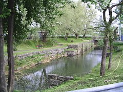
lock
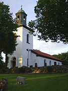
Church in Lilla Edet (Fuxernas kyrka)


Web links
Individual evidence
- ↑ a b c d Statistiska centralbyrån : Land area per crime scene, folkmängd and invånare per square kilometer. Vart femte år 1960 - 2015 (database query)
Perpetrator: Alvhem (part) | Göta | Hardship | Lilla Edet | Lilla Edet västra | Lödöse | Nygård | Signehög och Norrmannebo (part)
Småorter: Ballabo och Kyrkeby | Balltorp | Garn och Eckene | Groröd | Helltorp och Heden | Hede och Munkängen | Lekvall | Prässebo | Sollum | Svenseröd | Vabacken, Metholmen och Ekebergsdalen | Vests