Lilongwe (river)
| Lilongwe | ||
|
The Lilongwe / Linthipe system in the catchment area of Lake Malawi (bottom middle) |
||
| Data | ||
| location |
Central region of Malawi |
|
| River system | Zambezi | |
| Drain over | Linthipe → Lake Malawi → Shire → Zambezi → Indian Ocean | |
| muzzle | In Salima in the Linthipe coordinates: 13 ° 47 '0 " S , 34 ° 25' 9" O 13 ° 47 '0 " S , 34 ° 25' 9" O |
|
| Mouth height |
503 m
|
|
| length | 200 km | |
| Big cities | Lilongwe | |
| Medium-sized cities | Salima | |
|
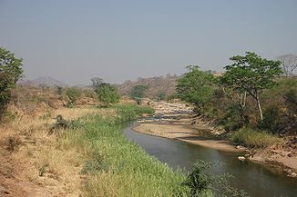
The Lilongwe at Thuma |
||
The Lilongwe a river in Malawi ,
course
Just like that is Dwangwa and the Bua it drains the central highlands. All three rivers have deep valleys, creating geographical subdivisions.
The Lilongwe is about 200 km long and has its headwaters on the east side of Dzalanyama mountain chain, meanders to the capital, Lilongwe , then flows through the Lilongwetal, the railway line winds at the northern slope, reached Salima , where he in the Linthipe . Empties
Naming
The name of the river after the union at Salima up to the confluence with Lake Malawi, which is 15 km further, is not clear. Depending on the source, the Lilongwe or the Linthipe are named as the main river; or the river system called Lilongwe / Linthipe. Most sources, however, name the Linthipe as the main river.
fishing
According to the FAO, the Bua , Dwangwa , Lilongwe, Lufira , Northern Rukuru , Songwe and Southern Rukuru rivers together have an annual fishing potential of 15,000 t. Between 4,000 and 17,000 t are actually caught.

