Lippinghauser Bach
| Lippinghauser Bach | ||
|
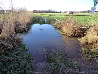
Lippinghauser Bach, ford in Sundern |
||
| Data | ||
| Water code | DE : 46524 | |
| location | North Rhine-Westphalia , Germany | |
| River system | Weser | |
| Drain over | Düsedieksbach → Werre → Weser → North Sea | |
| source | At Lippinghausen 52 ° 9 '22 " N , 8 ° 37' 37" E |
|
| Source height | approx. 98 m above sea level NN | |
| muzzle | At Sundern in the Düsedieksbach coordinates: 52 ° 8 '9 " N , 8 ° 38' 42" E 52 ° 8 '9 " N , 8 ° 38' 42" E |
|
| Mouth height | 63.4 m above sea level NN | |
| Height difference | approx. 34.6 m | |
| Bottom slope | approx. 11 ‰ | |
| length | 3 km | |
| Catchment area | 5.5 km² | |
| Communities | Hiddenhausen | |
The Lippinghauser Bach is a left tributary of the Düsedieksbach in the northeast of the German state of North Rhine-Westphalia .
geography
The water has a total length of 3 km. The catchment area extends over part of the Ravensberger Mulde in the municipality of Hiddenhausen. The water rises west of Lippinghausen and flows into the Düsedieksbach near Sundern (river kilometer 1.9).
See also
Web links
Commons : Lippinghauser Bach - Collection of images, videos and audio files
