List of National Natural Landmarks in Hawaii
This is a list of the National Natural Landmarks in Hawaii . There are seven National Natural Landmark properties in Hawaii (as of 2020). They were established between 1962 and 1972 and cover areas between about 51 hectares and 340 square kilometers .
list
| Surname | image | registration | place | county | Landowner | description | |
|---|---|---|---|---|---|---|---|
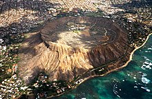
| 1 | Diamond Head |

|
1968 |
Honolulu 21 ° 15 ′ 43 " N , 157 ° 48 ′ 20" W. |
Honolulu County | Country | Towering tufa formation located in the heart of downtown Honolulu. |
| 2 | Īao Valley |

|
1972 |
Wailuku 20 ° 52 ′ 51 ″ N , 156 ° 32 ′ 42 ″ W. |
Maui County | Country | Eroded volcanic peaks overgrown with plants and surrounded by a lush rainforest. |
| 3 | Kanaha Pond |

|
June 1971 |
Kahului 20 ° 53 ′ 42 " N , 156 ° 27 ′ 32" W. |
Maui County | Country | A sanctuary for water birds. |
| 4th | Koʻolau Range Pali |

|
1972 | 21 ° 27 ′ 0 ″ N , 157 ° 54 ′ 0 ″ W. | Honolulu County | State, private | The rugged, eroded mountain range is the remnant of a shield volcano. |
| 5 | Makalawena Marsh |

|
June 1972 |
North Kona 19 ° 47 '32 " N , 156 ° 1' 31" W. |
Hawaii County | State (State Park) | Located in Kekaha Kai State Park , the site is home to critically endangered birds such as the Hawaiian stilt . |
| 6th | Mauna Kea |

|
November 1972 |
Saddle Road 19 ° 49 ′ 45 ″ N , 155 ° 27 ′ 36 ″ W. |
Hawaii County | Federation, state | The 4205 m high mountain is a world-famous example of a shield volcano. |
| 7th | North Shore Cliffs |

|
December 1972 |
Moloka'i 21 ° 8 '45 " N , 156 ° 51' 45" W. |
Maui County | Federal, state, private | Contains steep, eroded volcanic cliffs. |
See also
Web links
Individual evidence
- ↑ a b National Park Service: National Natural Landmarks by state , accessed on May 15, 2020 (English)