List of natural monuments in the Altenburger Land district
In the list of natural monuments in the Altenburger Land district , the 19 natural monuments in the area of the Altenburger Land district in Thuringia are listed.
Natural monuments
| No. | designation | Botanical name | location | District | description | image |
|---|---|---|---|---|---|---|
| Münsaer Linden | 50 ° 59 ′ 1 ″ N , 12 ° 27 ′ 48.6 ″ E | Altenburg | Old linden trees with a trunk circumference of over 150 centimeters along Münsaer Straße. | |||
| Leipzig linden trees | 50 ° 59 ′ 32.6 " N , 12 ° 26 ′ 43.8" E | Altenburg | Old linden trees with a trunk circumference of over 150 centimeters along Leipziger Strasse. | |||
| Geraer Linden | 50 ° 58 ′ 55.6 " N , 12 ° 24 ′ 45.7" E | Altenburg | Old linden trees with a trunk circumference of over 150 centimeters along Geraer Straße. | |||
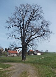
| 1000 year old oak | Quercus robur | 50 ° 52 '25.6 " N , 12 ° 16'53.1" E | Nöbdenitz | The tree is considered to be the second oldest oak in the world. |
 |
|
| Oak on the bird spruce | 50 ° 52 '3.4 " N , 12 ° 17" 24.4 " E | Nöbdenitz | In the 19th century the von Thümmel family was buried in the forest of the Raudenitz mountain south of the Nöbdenitz castle. Their ancestor Hans Wilhelm von Thümmel bought the so-called "grave oak" for himself in the village of Nöbdenitz, where he was also buried. The mausoleum was (presumably) destroyed after the Second World War. | |||
| Peace Oak (from 1871) | 50 ° 53 '43.4 " N , 12 ° 20' 28.3" E | Schmoelln | The Peace Oak is a memorial tree and commemorates the Franco-Prussian War of 1870–71. | |||
| Linde at the W. Kluge gymnasium | 50 ° 53 '52.8 " N , 12 ° 20' 51.7" E | Schmoelln | ||||
| War oaks in grief | 50 ° 52 ′ 6.6 " N , 12 ° 22 ′ 16.3" E | Grief |
 |
|||
| "The Höhgiebel" | 50 ° 56 '3.8 " N , 12 ° 15' 24.1" E | Small exchange |

|
|||
| Black pine in Mohlis | 50 ° 55 '12 " N , 12 ° 17' 58.6" E | Mohlis | ||||
| Larch on Heerstrasse | 50 ° 54 ′ 21.2 " N , 12 ° 18 ′ 20.5" E | Drugs | Larch in the southern parish corridor "An der Heerstraße" - today a connecting path between the towns of Nödenitz and Wildenbörten. | |||
| Kastanienbaum Kornhausstrasse | The Dobitschen train stop with beer garden was built at the former grain store, which was used as a regional grain warehouse in the 19th century. | 50 ° 57 '45.7 " N , 12 ° 16'23.5" O | Dobitschen | |||
| Linden tree from 1736 at the cemetery | 50 ° 56 '58.2 " N , 12 ° 19' 3.7" E | Göllnitz | ||||
| 5 English oaks | 51 ° 0 ′ 2.2 " N , 12 ° 28 ′ 26.5" E | Remsa | ||||
| Village oak | 50 ° 54 '43.6 " N , 12 ° 30' 26.3" E | Tautenhain |

|
|||
| Wolfenholz sandstone quarry | 51 ° 0 ′ 0 " N , 12 ° 26 ′ 57.8" E | Altenburg | Immediately on Leipziger Strasse, in the north of Altenburg, sandstone has been quarried for building materials since the Middle Ages. The abandoned quarry was reforested. | |||
| Tuber stones | 50 ° 57 '29.9 " N , 12 ° 23" 19 " E | Schlöpitz | Tertiary brown coal quartzites in the river bed of the Blue Tide . |
Area natural monuments
A total of 32 area natural monuments have been identified in the Altenburger Land district.
| No. | designation | Botanical name | location | District | description | image |
|---|---|---|---|---|---|---|
| Fairy tale lake | 50 ° 59 '7.4 " N , 12 ° 34" 0.1 " E | Langenleuba-Niederhain | water-filled former quarry in the Leinawald |
 |
||
| The Drosener rubble pits | ||||||
| Paditzer Schanzen | 50 ° 57 ′ 48.2 " N , 12 ° 27 ′ 41" E | Paditz |
 |
|||
| Pleißelauf | Celery - Kotteritz | |||||
| The course of the Pleiße river | Remsa Windischleuba and Saara-Kotteritz | |||||
| Gerstenbachaue | ||||||
| Enlightened | Heyersdorf | |||||
| The Nörditzer Heide |
See also
- List of nature reserves in the Altenburger Land district
- List of cultural monuments in the Altenburger Land district
Web links
Commons : Natural monuments in the Altenburger Land district - collection of images, videos and audio files
- TLUG home page - Map services of the Thuringian State Institute for Environment and Geology
- Thuringian Environmental Portal Map service of the Thuringian Environmental Portal