Paditz
|
Paditz
City of Altenburg
Coordinates: 50 ° 58 ′ 0 ″ N , 12 ° 27 ′ 34 ″ E
|
|
|---|---|
| Height : | 179 (178-223) m above sea level NHN |
| Area : | 1.62 km² |
| Residents : | 103 (December 31, 2010) |
| Population density : | 64 inhabitants / km² |
| Incorporation : | 7th September 1973 |
| Incorporated into: | Ehrenberg |
| Postal code : | 04600 |
| Area code : | 03447 |
|
Location of Paditz in the city of Altenburg
|
|
Paditz is a location in the Ehrenberg district of the Skat town of Altenburg in the Altenburger Land in Thuringia . It gained fame mainly through the Paditzer Schanzen area natural monument .
geography

The core town is on the left-hand side in the east of the Pleiße river , but the agglomeration with the former train station is also on the right-hand side of the water. The flowing water forms meanders , with the banks being protected from further washout by trees. Furthermore, the area natural monument, the Paditzer Schanzen between Paditz and Stünzhain, connects above the Paditz stop , where a volcanic rock (formerly known as mica porphyrite ) was extracted from the disused quarries .
history
Paditz is still recognizable today as a Sorbian round foundation through the eight courtyards around the central village center. The place was first mentioned in a document from the Naumburg bishopric between 1181 and 1214. At the time of German settlement, an extension was built. In the 13th and 14th centuries, the burgraves of Altenburg owned the place. Paditz later belonged to the Wettin office of Altenburg , which was under the sovereignty of the following Ernestine duchies from the 16th century due to several divisions in the course of its existence : Duchy of Saxony (1554 to 1572), Duchy of Saxony-Weimar (1572 to 1603), Duchy of Saxony- Altenburg (1603 to 1672), Duchy of Saxe-Gotha-Altenburg (1672 to 1826). When the Ernestine duchies were reorganized in 1826, the place came back to the duchy of Saxony-Altenburg. After the administrative reform in the duchy, Paditz belonged to the eastern district (until 1900) and to the Altenburg district office (from 1900).
From 1918 Paditz belonged to the Free State of Saxony-Altenburg , which was added to the State of Thuringia in 1920. Since 1922 the place was in the district of Altenburg and from 1952 in the district of Altenburg in the district of Leipzig , which had belonged to Thuringia as the district of Altenburg since 1990 and was added to the district of Altenburger Land in 1994. Before Paditz was incorporated into Ehrenberg on September 7, 1973 , it was an independent municipality with the district of Zschechwitz , which was added on July 1, 1950 by resolution of the state parliament. On July 14, 1993, the entire community of Ehrenberg was incorporated into Altenburg as a district.
Population development
- 1939-195
- 1997 - 119
- 1999-136
- 2001 - 122
- 2002 - 131
- 2005 - 118
Infrastructure
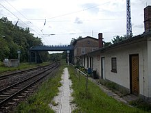
Since 1886, Paditz had a stop on the Leipzig – Hof railway line ; the trains have been going through without stopping since 2010. There is also a connection to the federal highways 7 , 93 and 180 approximately three kilometers away. Resident companies are a machine sales company and a used car dealer.
Attractions
In addition to the typical half-timbered courtyards that can be found in many places in the Altenburger Land, the Paditzer Schanzen nature reserve is of great cultural importance, which is unique in its shape and size for this region.
An important architectural feature in the place is the stone arch bridge over the Pleiße. It was built in 1531 on the site of an old ford on the trade route to Bohemia .
Individual evidence
- ^ Dietrich Zühlke et al .: The Altenburger Land . Akademie-Verlag, Berlin 1973, pp. 183-184
- ^ Dietrich Franke: Altenburger biotite-phenoandesite . In: Regional Geology of Eastern Germany (Saxony, Thuringia, Saxony-Anhalt, Brandenburg, Mecklenburg-Western Pomerania) Dictionary of regional geological terms, online at www.regionalgeologie-ost.de
- ^ Wolfgang Kahl: First mention of Thuringian towns and villages. A manual. Rockstuhl Verlag, Bad Langensalza, 2005, ISBN 3-937135-61-8 , p. 119
- ^ History of the Burgraves of Altenburg, p. 59
- ^ The Altenburg Office in the book "Geography for all Stands", from p. 201
- ^ The locations of the Altenburg district from p.83
- ↑ The eastern district of the Duchy of Saxony-Altenburg in the municipal directory 1900
- ^ The Altenburg district office in the municipality register 1900
- ↑ Paditz on gov.genealogy.net
- ↑ The Paditz stop on www.sachsenschiene.net


