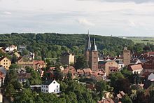
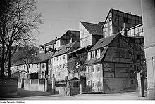
Altenburg suburbs
The suburbs of the East Thuringian skat and residence town of Altenburg are arranged in a ring around the old town and represent the extension of the residential development of this. The suburbs represent historically grown settlements in the district of Altenburg, the villages that are incorporated into the agglomeration of the city and planned districts do not count.
The city has a total of 19 suburbs that have emerged in the course of history. Eleven of them already existed in the Middle Ages, the rest of them date from the second half of the 19th and 20th centuries.
history
Medieval suburbs


The first Altenburger suburb is mentioned at the same time as the later city itself in 976. This Sorbian foundation, Podegrodici , later called Ober- and Unterpauritz , was a service settlement of the Sorbian aristocratic castle in the area of today's residential palace . Podegrodici means something like 'people under the castle'. Since the area was increasingly populated by Slavic tribes from 800 onwards, the suburb is probably older than Altenburg itself, which was the main town of a Burgward. At this time a fortification was also built, making Podegrodici a suburb due to its location outside of it. The main expansion as a city took place under Emperor Friedrich I Barbarossa , who also founded the Bergerkloster in 1165 . In the 13th century this received some goods from Pauritz from the possession of the Burgraves of Altenburg .
A settlement also arose around the Bergerkloster, which developed into the upper and lower communities of Unterm Berg . This is followed by the Frauenfels community ; the suburb Hinter der Mauer is located directly on the city wall on today's Wallstrasse . Naschhausen , which was first mentioned in a document in 1275 and named Untererm Schloss from 1548, extends directly south of the castle . The Neue Sorge stretches to the northeast of the castle and is connected to Hinterm Schloss to the south .
Further suburbs are located outside the city gates. In front of the Schmöllnschen Tor in the southwest of the old town is the Schmöllnsche Vorstadt . Outside the double gate system of the Johannistor is the Johannisvorstadt , also called Vorm Johannistor . The pond suburb connects to the pond gate in the southeast of the old town .
All these suburbs were formally subordinated to the city in the new city constitution of July 1, 1831 during the beginning of industrialization , i.e. incorporated. They had a population of 4230 people. The step had become necessary because the population of the old town had continued to grow within the city wall. In addition, Altenburg was again the main residence of the Duchy of Saxony-Altenburg from 1826 . The suburbs belonged to the ducal office of Altenburg , but due to their location within the border of Altenburg, city law applied.
Suburbs that emerged later

During the course of the 19th century and the beginning of the 20th century, eight new districts emerged during industrialization . The starting point for this was the railway connection in 1842. The northern suburb has been developing since 1865 on Lindenau and Zeitzer Strasse, where mainly villas were built as the residence of officials. In 1895 today's district office was completed. With the construction of the new station in 1878, the expansion of the station district or the lower town began in 1880 . Most of the factories and workers' homes were built there on Uferstrasse, Canalstrasse, Factory Strasse, Terrassenstrasse and Wettiner Strasse. Both quarters grew together from 1886 to form the northern suburb, when Garten- (Dr. Wilhelm-Külz-Straße), Nord-, Wilhelm- (Dostojewskistraße) and Hohe Straße (Carl-von-Ossietzky-Straße) were laid out. The prison, built towards the end of the 19th century, operated until 1990 and was demolished in 2004 and 2011, respectively. The power station was built on Ziegelstrasse (Franz-Mehring-Strasse) in 1895 and also operated the tram , which began operating in the same year.

Leipziger Straße as the main street in the east of the city was laid out around 1720. At the beginning of this, the Herzog-Joseph barracks was built in 1845 , which is now used by the police and the labyrinth house, a themed and backdrop labyrinth. However, it was too small for the 8th Thuringian Infantry Regiment founded in 1897 and so the Herzog-Ernst barracks was built further out of town on Leipziger Strasse , which, however, is located in the Rasephas district. The first cross street to Leipziger Straße was built around 1900 with Poschwitzer Straße (Beethovenstraße). Poschwitzer Platz (Richard-Wagner-Platz) was built around 1905, where the first new apartments were handed over to tenants in 1955 . The slaughterhouse built between 1900 and 1902 already existed on the adjacent Brunnenstrasse, the main building of which is still standing, and a photovoltaic system was installed on the rest of the site in 2010. In the further course of Brunnenstrasse, as well as in Mozartstrasse, today's Poschwitzer and Mitschurinstrasse (today Christian-Friedrich-Witt-Strasse), private homes were built in GDR times. The falcon or bird settlement , a garden city with single-family houses, was built south of the railway line after 1930 .
From 1874, the New World was the first of the four eastern suburbs, now also known as the researchers' quarter. This working-class district includes Theresen- (Erich-Mäder-Straße), Bauhof- (Spinozastraße), Adelheid- (Darwinstraße), Ost- (Newtonstraße), Karl- (Rousseaustraße) and Elisenstraße (Albert-Einstein-Straße) and is part of the Münsaer Strasse demarcated. In May 2014, the former ducal arsenal, which was built in 1712 and housed the Altenburg professional fire brigade from 1921 to 2012 , was demolished and a supermarket was built on the site. Between Kotteritzer Strasse (Käthe-Kollwitz-Strasse) and Stiftsgraben, the so-called Wilhelminian - era district was built around 1910 , the development is characterized by Art Nouveau and historicist architecture . The district includes Mauer-, Thümmel-, Hempel-, Meißner-, Körner-, Wieland-, Friesen- and Arndtstraße (Heinrich-Mann-Straße). Even back then, green spaces were important, as evidenced by the Friesenplatz, which is now a playground. Around 1920, the Dichterviertel with Schiller-, Goethe-, Lessing- and Kleiststraße was built in the Bauhaus style to the east . Enclosed by Magdalenenstift in the north, Neuer Welt in the east, Dichterviertel in the south and Gründerzeitviertel in the west, today's Sperlingsbergsiedlung with 308 old new apartments was built between 1958 and 1962 on what was known as the Erich-Weinert-Höhe in GDR times . In September 2012, a four-storey residential building with 32 apartments directly on Münsaer Strasse was demolished, and a four to five-storey senior-friendly residential complex with 52 apartments was built on this area by December 2014.
The first buildings in the southern suburb already existed in 1831, but the actual expansion took place around the turn of the 19th and 20th centuries. It extends between Schmöllnscher Landstrasse in the west and Käthe-Kollwitz-Strasse in the east. The Wilhelminian style development extends mainly to Bach- (August-Bebel-Straße), Paditzer, Zwickauer and Brauhausstraße, which led from Schmöllnschen Landstraße to the communal brewery founded in 1871 . The Südvorstadt received significant expansions in the 1920s and 1930s. Brauhausstrasse and Talstrasse received new buildings, and the adjacent Spinnbahn and Braugartenweg streets were also laid out. Also on the Käthe-Kollwitz-Straße, the Südstraße was built, where multi-family houses were built in the Bauhaus style . After 1930, the Südstrasse was extended to Paditzer Strasse to include single-family houses. The Südvorstadt is the green lung of the city, here is the large pond with the island zoo , the outdoor and indoor swimming pool and the Herzog-Ernst- or Stadtwald , which was reforested in 1907 and in which the skatbank arena, inaugurated in 1957, is located.
The Weststadt is on the left side of Schmöllnscher Landstraße, Puschkinstraße, Am Steinweg and Zeitzer Straße. The main road is Geraer Strasse. The origin of the western city, however, is the stone path , which was paved as early as 1459 and leads to the Hospital of the Holy Spirit . This is followed by the churchyard . The current buildings were built in 1771 and 1863/64, the so-called New Hospital was built from 1843 to 1846. The Church of the Holy Spirit was demolished in 1860, the Gottesackerkirche, which is still standing today, was built between 1639 and 1650. The square on Steinweg was redesigned during GDR times, so new buildings were built in 1968 and 1983 and a department store in 1978. In 1973 a connecting road (Am Steinweg) was created between Puschkinstrasse and Zeitzer Strasse, with some buildings having to give way. To the west of the Schmölln suburb is the meadow on which the rifle house was located, followed by a gymnasium with a gym. In 1948 the Altenburger distillery and liquer factory settled on the Anger . The buildings on the cross streets between Geraer Strasse and Mittelstrasse were built around 1900. The Reichenbach Hospital on Geraer Strasse was built between 1885 and 1887 , along with the Friedrichgymnasium, built between 1899 and 1902 . Lossener and Steinwitzer Strasse were also laid out around 1900, but mainly single-family houses were built on during the GDR era. The first cooperative houses in Altenburg were built between 1920 and 1930 on Sternstrasse and Gabelsbergerstrasse. This is followed by the Osterlandcenter built in 1992/93 . After 1930 the single-family houses on Blumenstrasse and Grüntaler Weg were built. The only residential estate in Altenburg that emerged after reunification from 1993 is the Goldene Glucke on Schmöllnschen Landstrasse.
District office in the north suburb
Winselmann sewing machine factory in Südvorstadt
Other districts
Altenburg expanded mainly to the north, so the agglomerations of the city merged with those of the villages of Kauerndorf , Rasephas and Zschernitzsch . While the latter retained its village character, Kauerndorf developed into a real workers' settlement, whose residents were employed in the nearby factories in the northern suburbs. Rasephas partially retained its village character, but between 1922 and 1926 the railway settlement was built as the largest garden city in Thuringia. The residents worked in the signal boxes of the station. Between these three districts and the northern suburbs, the Lerchenbergsiedlung was built between 1958 and 1964 and Altenburg-Nord from 1975 . In the east and west, the districts of Poschwitz and Drescha were incorporated, which largely retained their village character. To the south, the Altenburg-Südost district was built between 1971 and 1975 .
Suburbs
swell
- The Altenburger Land (= values of our homeland . Volume 23). 1st edition. Akademie Verlag, Berlin 1973.
- Altenburg districts on the AWG website


