Lizerne (river)
| Lizerne | ||
|
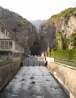
Exit of the Lizerne gorge at the Ardon power station with the remains of a bisse |
||
| Data | ||
| Water code | CH : 4040 | |
| location | Switzerland | |
| River system | Rhône | |
| Drain over | Rhône → Mediterranean | |
| source | at Sex Rouge 46 ° 17 ′ 55 ″ N , 7 ° 16 ′ 14 ″ E |
|
| Source height | 2119 m above sea level M. | |
| muzzle | Near Ardon in the Rhône Coordinates: 46 ° 11 ′ 58 " N , 7 ° 16 ′ 57" E ; CH1903: 587 954 / 116450 46 ° 11 '58 " N , 7 ° 16' 57" O |
|
| Mouth height | 475 m above sea level M. | |
| Height difference | 1644 m | |
| Bottom slope | 11% | |
| length | 14.8 km (approx. 19.5 km with the longest spring stream) | |
| Catchment area | 64.4 km² | |
| Discharge at the A Eo estuary gauge : 64.4 km²
|
MQ Mq |
2.65 m³ / s 41.1 l / (s km²) |
| Communities | Conthey , Vétroz , Ardon | |
|
The license in Ardon |
||
The Lizerne (in the upper reaches of Lizerne de la Mare , formerly Liserne ) is an approximately 15 kilometer long tributary of the Rhône in the canton of Valais. It rises in a high valley near the border with the canton of Vaud below the peaks of Sex Rouge , Tête Noire (2,451 m) and La Fava (2,612 m). The source tributaries form several rivulets in an alpine scree field . Only a few 100 meters below this source zone is a small reservoir that is used to control the water supply.
In its middle course it takes in the Derbonne torrent (also called Lizerne de Derborence in the lower reaches ) coming from the west, which previously left the Lac de Derborence . After around 15 kilometers, the Lizerne joins the Rhône near Ardon .
In the middle of the stream there is a gorge with almost vertical rock walls. A small road that leads from the village of Vétroz passes this gorge with the help of several small, winding and unlit tunnels. At the exit of this gorge there is a hydroelectric power station that receives its supply from the catchment area of the Lizerne. In the immediate vicinity you can see the artificial course of an old bisse , which was hung on the rock wall.
The water in the Lizerne is partly used for drinking water. The municipality of Vetroz participates in this in a special way, drawing it with pumps at three points.
See also
literature
- Office fédéral de topographie: Carte Nationale de la Suisse 1: 25,000 . Sheet 1285 Les Diablerets (Wabern 2000), Sheet 1306 Sion (Wabern 2001), Sheet 1286 St-Léonard (Wabern 2001)
Individual evidence
- ↑ a b c d Geoserver of the Swiss Federal Administration ( information )
- ↑ Modeled mean annual discharge. In: Topographical catchment areas of Swiss waters: area outlets. Retrieved November 1, 2015 .
- ↑ Comune de Vétroz: Les Eaux de Vétroz. on www.vetroz.ch ( page no longer available , search in web archives ) Info: The link was automatically marked as defective. Please check the link according to the instructions and then remove this notice.

