Lyubovija
|
Љубовија Ljubovija |
||||
|
||||
| Basic data | ||||
|---|---|---|---|---|
| State : | Serbia | |||
| Okrug : | Okrug Mačva | |||
| Coordinates : | 44 ° 11 ' N , 19 ° 22' E | |||
| Height : | 174 m. i. J. | |||
| Residents : | 4,130 (2002) | |||
| Telephone code : | (+381) 015 | |||
| Postal code : | 15320 | |||
| License plate : | LO | |||
| Structure and administration | ||||
| Community type: | Town | |||
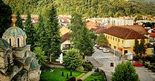
Ljubovija ( Serbian - Cyrillic Љубовија ) is a small town in the Opština Ljubovija of the same name in the Okrug Mačva in western Serbia .
geography
Ljubovija is a border town between Serbia and Bosnia and Herzegovina . Only the Drina separates the city from the neighboring country. The Ljuboviđa flows through the city and flows into the Drina at Ljubovija. Beekeeping has been practiced in Ljubovija for a long time .
population
In 2002, 4130 people lived in the city, while in 1991 there were only 3663 residents. Serbs make up the majority of the population . In addition, there are still smaller minorities of Yugoslavs , Montenegrins , Macedonians , Roma , Croats , Russians , Bosniaks and Hungarians . The city consists of 1315 households.
Demographics
| year | population |
|---|---|
| 1948 | 597 |
| 1953 | 660 |
| 1961 | 1142 |
| 1971 | 1614 |
| 1981 | 2717 |
| 1991 | 3663 |
| 2002 | 4130 |
history
In 1837, infrastructure began to be created in the area of what is now Ljubovija . In 1860 the village of Ljubovija was established there. On July 3, 1871, Ljubovija was granted city rights. The town charter was a decree of King Milan Obrenović . In 1896 a devastating flood of the Drina destroyed the city and the residents rebuilt their city three kilometers north on the lower reaches of the Drina tributary Ljubovica. This area is a little further away from the Drina.
Rapid development of the city delayed the Balkan Wars , World War I and World War II . During the First and Second World Wars, many of the residents of Ljubovija died, as did many from the surrounding villages. From 1941 to 1945, residents of the city belonged to the communist partisans , but also to the nationalist Chetniks .
It was not until the 1980s that the small town experienced an upswing and the first factories were built.
The Vuk Karadžić elementary school is located in the town. The Serbian Orthodox Church of the Transfiguration was built from 1932 to 1940.
sons and daughters of the town
- Miroslav Stević (* 1970), former soccer player and current soccer official
- Slaviša Pavlović (* 1982), writer and poet
literature
- Dragutin J. Deroko: Drina. Geografsko-turistička monografija. Izdanje društva Fruška gora, Novi Sad 1939; Reprint: Cigojna štampa, Beograd 2004, ISBN 86-7558-299-4 , pp. 201–203.
Web links
Individual evidence
- ↑ Књига 9, Становништво, упоредни преглед броја становника 1948, 1953, 1961, 1971, 1981, 1991, 2002, подаци по насељима, Републички завод за статистику, Београд, мај 2004, ISBN 86-84433-14-9
- ↑ Књига 1, Становништво, национална или етничка припадност, подаци по насељима, ISBN , Реповништво, Репионална или етничка 2003, подаци по насељима, Репиовништво, Репионална, ас-, Бас, Баскана, Бас-, Бас, Бассеима, ISBN , Репсеима
- ↑ Књига 2, Становништво, пол и старост, подаци по насељима, Републички завод за статистику, Београд, фебруар 2003, ISBN 86-84433-01-7


