Louisa (Kentucky)
| Louisa | |
|---|---|
 |
|
| Location in Kentucky | |
| Basic data | |
| Foundation : | 1822 |
| State : | United States |
| State : | Kentucky |
| County : | Lawrence County |
| Coordinates : | 38 ° 7 ′ N , 82 ° 36 ′ W |
| Time zone : | Eastern ( UTC − 5 / −4 ) |
| Residents : | 2,467 (as of 2010) |
| Population density : | 704.9 inhabitants per km 2 |
| Area : | 3.6 km 2 (approx. 1 mi 2 ) of which 3.5 km 2 (approx. 1 mi 2 ) are land |
| Height : | 178 m |
| Postcodes : | 41201, 41230 |
| Area code : | +1 606 |
| FIPS : | 21-47854 |
| GNIS ID : | 0497204 |
| Website : | www.cityoflouisa.com |
| Mayor : | Teddy Preston |
 |
|
Louisa is a small town (City) and seat of the county administration ( County Seat ) in Lawrence County in the US state of Kentucky .
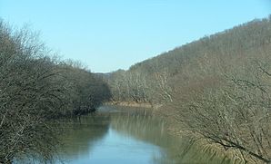
The place is in northeast Kentucky, on the border with West Virginia . The entire length of the border between Kentucky and West Virginia is covered by the two border rivers, the Tug Fork in the south and the Big Sandy River in the north. At Louisa, the Levisa Fork is responsible for the name change due to the confluence. The Big Sandy River flows into the Ohio after just 40 kilometers .
Personalities
- Laban T. Moore (1829-1892), politician
- John McConnell Rice (1831–1895), politician
- Fred M. Vinson (1890-1953), politician
Web links
Commons : Louisa, Kentucky - Collection of pictures, videos, and audio files