Luidbach
|
Luidbach Ludbach |
||
|
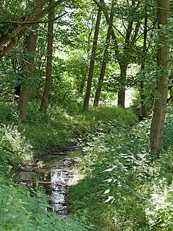
Luidbach shortly before it flows into the Windmühlenbruch |
||
| Data | ||
| location | Nettetal , Lower Rhine region , North Rhine-Westphalia , Germany | |
| River system | Rhine | |
| Drain over | Nice → Niers → Maas → Hollands Diep → North Sea | |
| River basin district | Meuse | |
| source | In Oberbocholt ( Lobberich ) | |
| Source height | 74 m above sea level NN | |
| muzzle | In the Windmühlenbruch ( Nette lakes ) coordinates: 51 ° 18 ′ 19 ″ N , 6 ° 16 ′ 2 ″ E 51 ° 18 ′ 19 ″ N , 6 ° 16 ′ 2 ″ E |
|
| Mouth height | 46 m above sea level NN | |
| Height difference | 28 m | |
| Bottom slope | 6.8 ‰ | |
| length | 4.1 km | |
| Catchment area | 7 km² | |
The Luidbach or also just called Ludbach , is a 4.1 km long brook in Nettetal - Lobberich , it is a tributary of the Nette .
course
The Ludbach rises in Oberbocholt, a district of Lobberich , the source of the Ludbach has dried up due to the Garzweiler II open-cast lignite mine . The first three kilometers of the Ludbach are now used exclusively for draining the fields west of Lobberich. In Ingenhoven Park behind Ingenhoven Castle , the Ludbach has an artificial spring, from where it carries water permanently. After about 100 meters it flows through the Ingenhovenweiher, behind the pond the Ludbach runs underground for about 400 meters, while it crosses under the Hochstraße, the Freiheitsstraße and the Ludbach-Passage named after it. It then returns to the surface for a few meters before disappearing under the fenland ring. It then flows between the streets of Fenland-Ring and Am Ludbach until it crosses Mühlenstraße shortly before its confluence. Ultimately it flows into the Windmühlenbruch and thus into the Nette.
Individual evidence
- ↑ a b German basic map 1: 5000
- ↑ a b Topographical Information Management, Cologne District Government, Department GEObasis NRW ( Notes )
