Lundershausen
|
Lundershausen
City and rural community An der Schmücke
Coordinates: 51 ° 16 ′ 2 ″ N , 11 ° 16 ′ 6 ″ E
|
||
|---|---|---|
| Height : | 250 m above sea level NN | |
| Postal code : | 06577 | |
| Area code : | 034673 | |
|
Location of Lundershausen in Thuringia |
||
|
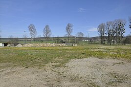
The area of the former manor with a pile of stones, the remains of the demolished ruin.
|
||
Lundershausen is a district of An der Schmücke in the Kyffhäuserkreis in Thuringia .
location
Lundershausen is located 250 meters west of Hauteroda and used to be an independent village with a church and a manor . The federal motorway 71 runs south near Hemleben .
history
The village was first mentioned on September 29, 1299. The Lundershausen homestead is now part of Hauteroda. The last remnants of the former manor were demolished on July 1, 2013 due to dilapidation by resolution of the municipal council. What is left is an undeveloped area with a pile of stones (see pictures).
Web links
Commons : Lundershausen - Collection of images, videos and audio files
Individual evidence
- ^ Wolfgang Kahl : First mention of Thuringian towns and villages. A manual. Rockstuhl Verlag, Bad Langensalza, 2010, ISBN 978-3-86777-202-0 , p. 171.
- ↑ The story on hauteroda.net.Retrieved June 1, 2012

