
Hemleben
|
Hemleben
City and rural community An der Schmücke
Coordinates: 51 ° 15 ′ 21 ″ N , 11 ° 13 ′ 28 ″ E
|
|
|---|---|
| Height : | 165 m |
| Area : | 7.33 km² |
| Residents : | 225 (Dec. 31, 2017) |
| Population density : | 31 inhabitants / km² |
| Incorporation : | 1st January 2019 |
| Postal code : | 06577 |
| Area code : | 034673 |
Hemleben (formerly Hemmleben ) is a district of the town and rural community of An der Schmücke in the Thuringian Kyffhäuserkreis south of the Schmücke mountain range.

location
Hemleben is located on the northeast edge of the Thuringian Basin and south of the Schmücke, east of the federal highway 71, which is currently under construction .
history
The first documentary mention as Hameleiven in a document from the Oldisleben monastery dates back to 1227 . The extinct knight family von Hemleben , which is documented from 1284 to 1422, probably had its ancestral seat here.
On January 1, 2019, the communities of Hemleben, Bretleben , Gorsleben , Hauteroda and Oldisleben as well as the country town of Heldrungen merged to form the new town and country community of An der Schmücke. The community Hemleben belonged to the administrative community An der Schmücke .
Population development
Development of the population (December 31) :
|
|
|
|
- Data source: Thuringian State Office for Statistics
Culture and sights
- Evangelical St. John's Church
- Atonement Cross from 1821
- War memorial for the fallen of both world wars
- Farms
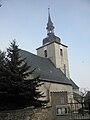
Church of St. Johannes in Hemleben

Church of St. Johannes in Hemleben
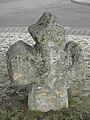
Stone cross in Hemleben

Fire station in Hemleben


