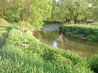
Moravian Thaya
| Moravian Thaya | ||
|
Moravian Thaya in Dačice -Hradišťko |
||
| Data | ||
| location |
Moravia ( Czech Republic ), Lower Austria ( Austria ) |
|
| River system | Danube | |
| Drain over | Thaya → March → Danube → Black Sea | |
| source | near Stajiště, 4 km southeast of Třešť 49 ° 16 ′ 0 ″ N , 15 ° 31 ′ 16 ″ E |
|
| Source height | 653 m nm | |
| muzzle | in Raabs an der Thaya with the Deutsche Thaya zur Thaya coordinates: 48 ° 50 ′ 52 ″ N , 15 ° 29 ′ 25 ″ E 48 ° 50 ′ 52 ″ N , 15 ° 29 ′ 25 ″ E
|
|
| length | 68.2 km | |
| Catchment area | 630 km² | |
|
Moravian Thaya Natural Monument |
||
The Moravian Thaya ( Moravská Dyje in Czech ) is the left source river of the Thaya .
It rises in the Czech Republic in the Bohemian-Moravian Highlands four kilometers southeast of Třešť near the village of Stajiště. The river leads in southern direction on Bezděkov, Panenská Rozsíčka , Urbanov , Žatec , Dyjice , Radkov , Slaviboř, Černíč , Velký Pěčín, Dačice , Touzin, Hradišťko, Vnorovice, Stare Hobzí , Janov, Nove Hobzí, Modletice Nove Sady and Písečné by Austria . There it runs via Unterpertholz, Oberndorf, Weikertschlag and Alberndorf to Raabs an der Thaya , where it joins the German Thaya zu Thaya after 68.2 km . It drains an area of 630 km².
A three-row bunker line of the Czechoslovak Wall , consisting of light fortifications, extends on the left slope of the valley between Janov and the border with Austria .
Tributaries
- Telčský potok (r) near Telč
- Myslůvka (r) near Černíč
- Vyderský potok (r) above Dačice
- Vápovka (l), Dačice
- Lipolecký potok, Toužín
- Bolíkovský potok at Staré Hobzí

