German Thaya
| German Thaya | ||
|
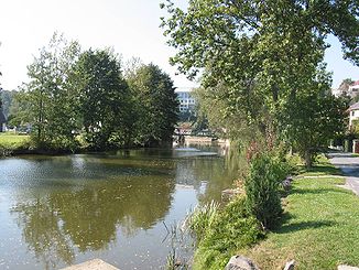
The Deutsche Thaya in Waidhofen |
||
| Data | ||
| location | Lower Austria ( Austria ) | |
| River system | Danube | |
| Drain over | Thaya → March → Danube → Black Sea | |
| source | near Schweiggers 48 ° 39 ′ 33 ″ N , 15 ° 2 ′ 22 ″ E |
|
| Source height | 657.5 m above sea level A. | |
| confluence | in Raabs an der Thaya with the Moravian Thaya to the Thaya Coordinates: 48 ° 50 ′ 52 ″ N , 15 ° 29 ′ 25 ″ E 48 ° 50 ′ 52 ″ N , 15 ° 29 ′ 25 ″ E
|
|
| length | 75.8 km | |
The German Thaya ( Czech Rakouská Dyje i. E. The Austrian Thaya) is a river in Lower Austria and one of two source rivers of the Thaya .
The Deutsche Thaya rises in the Waldviertel near Schweiggers at an altitude of 657.5 m . At the Schwedenkreuz on the road to Jagenbach, next to the Mödershöf estate , a narrow dirt road branches off, which leads to the secluded Thaya spring. After 75.8 km in Raabs an der Thaya, it joins the second source river of the Thaya, the Moravian Thaya . On its way there it flows through Vitis , Schwarzenau , Waidhofen an der Thaya , Thaya , Dobersberg , and Karlstein an der Thaya .
Tributaries
- Meinhartschlager Bach (l)
- Stoanathaya (l)
- Rotbach (r)
- Moosbach (l)
- Jaudlingbach (l)
- Aubach (r)
- Ganzbach (r)
- Thauabach (r) near Windigsteig
- Lenzbach (r)
- Großer Radlbach (l) near Waidhofen an der Thaya
- Kaltenbach (r) near Altwaidhofen
- Grenzbach (r)
- Sarningbach (l)
- Friedbach (r)
- Taxenbach (l)
- Lexnitzbach (l)
- Zlabingsbach (l)
- Edelbach (l)
- Schladeinbach (r)
- Mudlbach (l)
Web links
Commons : Deutsche Thaya - Collection of images, videos and audio files
