Zlabingsbach
|
Zlabingsbach Feinitzbach, Slavonický potok |
||
|
The stream in Slavonice (Zlabings) (photo 2004) |
||
| Data | ||
| location | Jihočeský kraj (Czech Republic) and Lower Austria | |
| River system | Thaya | |
| Drain over | German Thaya → Thaya → March (river) → Danube → Black Sea | |
| source | 700 m south of Stálkov 49 ° 2 ′ 3 ″ N , 15 ° 17 ′ 20 ″ E |
|
| Source height | 640 m nm | |
| muzzle | near Hanftal ( Waldkirchen an der Thaya ) in the German Thaya Coordinates: 48 ° 55 '40 " N , 15 ° 21' 47" E 48 ° 55 '40 " N , 15 ° 21' 47" E |
|
| Mouth height | 445 m above sea level A. | |
| Height difference | 195 m | |
| Bottom slope | 12 ‰ | |
| length | 15.9 km | |
| Catchment area | 45.5 km² | |
| Drain |
MQ |
270 l / s |
| Right tributaries | Mařížský potok / Gehringsbach | |
| Small towns | Slavonice (Zlabings) | |
| Communities | Waldkirchen an der Thaya | |
|
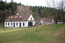
Bejčkův mlýn am Zlabingsbach (photo 2002) |
||
The Zlabingsbach (also Feinitzbach , Czech Slavonický potok ) is a left tributary of the German Thaya in Lower Austria and the Czech Republic . It drains over the German Thaya and the Thaya into the March , the Danube and thus into the Black Sea .
course
The brook rises 700 m south of Stálkov ( Stallek ) in the Bohemian-Moravian Highlands (another spring brook that flows through the two ponds of Šatlava, rises north of Stálkov on the edge of the Česká Canada Nature Park ), flows through several ponds (Pstruži rybník, Dědkův rybník, rybník Starý, Velký Spaleny, Malý Spaleny, Silničný rybník, Bejčkův rybník), while passing the site of the defunct village Pfaffenschlag and runs southeast to Slavonice ( Slavonice ), then turns south and crosses in Rabingmühle at Fratres the Czech-Austrian border. South of Waldkirchen an der Thaya , it flows into the German Thaya after a run of 15.9 km near Hanftal .


