
Mühlbach (Augsburg)
|
Mühlbach Unterlauf from the former Pferseer mill: Hettenbach |
||
 The Mühlbach in the Mühlbachviertel |
||
| Data | ||
| location |
Bavaria
|
|
| River system | Danube | |
| Drain over | Wertach → Lech → Danube → Black Sea | |
| introduction | the lower left Wertach on the eastern edge of Luitpold road in Augsburg - Pfersee of a siphon under the Wertach pass from the right Wertach channel forth | |
| Rewind | About 200 meters south of the corner of Ahorner Straße / Äußere Uferstraße in Augsburg- Oberhausen Süd from the left into the lowest Wertach coordinates: 48 ° 23 '22 " N , 10 ° 53' 11" E 48 ° 23 '22 " N , 10 ° 53 ′ 11 ″ O
|
|
| length | Length of the Mühlbach: 1.9 km, length of the Hettenbach: 2.65 km | |
The Mühlbach in Augsburg 's Pfersee district was originally a left channel of the Wertach . Today it is no longer fed directly from the Wertach, but from the Wertach Canal. In its further course it is called Hettenbach and flows through the Augsburg districts of Kriegshaber and Oberhausen . In the past, Hessenbach, which no longer exists, was part of his system .
The Mühlbach was an important pillar for the early industrialization of Pfersee. Its water volume is around 2 m³ / s. Four of the original eight hydropower plants are still preserved today. Together they generate 1.5 million kWh of power each year.
There is also a Mühlbach in the Augsburg city forest near Haunstetten . This is not the subject of this article.
History and course of the Mühlbach


The Mühlbach originally emerged from the Lorbach, which rises near Göggingen . In order to operate the Pferseer Mühle, a piercing of the Wertach was created, which strengthened this existing stream. After the Pferseer Mühle, the Mühlbach used to be divided into the Hettenbach and the Hessenbach . The origin of the names "Hettenbach" and "Hessenbach" is not known. Possibly they come from field names.
A little further south, the Ulm entrepreneur Johann Georg Krauss and his son Robert bought a piece of land on the Mühlbach in 1866 and built the "cotton spinning and weaving mill JG Krauss & Sohn" on it. The Mühlbach initially provided sufficient energy to operate the machines.
In 1876, the river bed of the Wertach was lowered as a flood protection measure ("correction"). As a result, the Wertachanstich zum Mühlbach could no longer be supplied. So that the Mühlbach could continue to operate, a new feed was built from the higher-flowing Wertach Canal in the form of a culvert , which crosses the river at the level of the Pfersee local railway bridge under its gravel bed from right to left and reappears in Pfersee.
In 1885 the Mühlbach was turned into a canal in order to be able to use its hydropower better industrially. The cotton spinning and weaving mill at Mühlbach became the joint stock company “Spinnerei und Buntweberei Pfersee” (SWP) in 1881. The “big factory”, as it was called in Pfersee, survived various challenges of the 20th century until the company came to an end in 1992/1993. In 1997, a residential area was built on the SWP site, which had meanwhile become a valuable building site for residential construction, and was named Mühlbachviertel . At this point, the Mühlbach was restored to a brook-like appearance over a length of around 150 m, surrounded by a small park, and the hydroelectric power plant, which had been shut down in the meantime, was reactivated.
The Pferseer mill

The old Pferseer mill, which gave the Mühlbach its name, belonged to the Sankt-Jakobsstiftung Augsburg. After several changes of ownership, the Pferseer "Mahl-Mühle" finally went to the company JN Eberle & Cie GmbH. Eberle has been producing springs and fretsaws here since 1885. The former Mühlstrasse, which led to the mill, is today's Kirchbergstrasse. Instead of the mill, there is now a small hydroelectric power plant, the "Limmert Mühlbach power plant".
Hessenbach

The right branch of the Mühlbach after the Pferseer Mühle, the Hessenbach , used to carry most of the water and flow back into the Wertach below the Goggeleswehr . It no longer exists today. In its place an underground alluvial canal was created, which branches off at Zweibrückenstrasse and leads to Wertach. It does not have an official name, its generic name comes from the fact that it was supposed to wash away the dumped waste and discharged sewage.
The names of Hessenbachstrasse and the street “Am Alten Hessenbach” are still reminiscent of the former stream and canal.
Hettenbach
Originally the Hettenbach was the left and smaller branch of the Mühlbach after the Pferseer Mühle. It flowed from Pfersee to Oberhausen, where it was used to irrigate the herb gardens and meadows there. Today the branch no longer exists - apart from the small alluvial canal - and almost the entire canal continues to flow in its former left branch. He changes his name on Zweibrückenstrasse from Mühlbach to Hettenbach. It then crosses under Bürgermeister-Ackermann-Strasse ( Bundesstrasse 300 ), flows a little parallel to Hessenbachstrasse and then crosses under the main railway tracks.
From here the Hettenbach flows through Oberhausen in a meandering course, which reveals its origin as a natural brook, and crosses under Ulmer Straße, Donauwörther Straße and Dieselstraße. A little north of Ulmer Straße there is a small park on Hettenbach with a water playground and a water wheel . After Donauwörther Strasse, the Hettenbach operates a hydroelectric power station . At the Bärenwirt level, it flows through the former Coca-Cola site. After Dieselstrasse, it crosses the building complex of the Deutsche Rentenversicherung , which was built on the site of the demolished ELBEO works, then the former Zeuna- Starker works and finally flows back further downstream than the former Hessenbach into the Wertach.

The Hettenbach a few meters north of Ulmer Straße
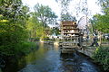
The water wheel at the water playground

The water playground

Small surge


Ecological improvement measures
Since 2009, voluntary ecological improvement measures have been taking place on the Mühlbach and, to a small extent, on the Hettenbach by the adjacent hydropower operators, which the legislature promotes through the Renewable Energy Sources Act of 2009. As a result of these measures, the operators receive an electricity charge that is 4 cents / kWh higher. Near-natural bank zones were designed with stones and vegetation, shallow water zones were created and the flow speed was reduced in individual places. So the Mühlbach from the industrial canal is to become more stream-like again and thus more attractive for people, animals and plants.
See also
Individual evidence
- ↑ a b c d City of Augsburg: The Mühlbachviertel, a piece of nature in Pfersee
- ↑ Source: Information board at the Mühlbach
- ↑ a b On the trail of robber barons, spinners and city councilors. Pfersee Citizens Action, accessed on May 16, 2019 .
- ↑ Entry ( Memento of the original from April 13, 2014 in the Internet Archive ) Info: The archive link was inserted automatically and has not yet been checked. Please check the original and archive link according to the instructions and then remove this notice. in the city lexicon Augsburg
Web links
- Entry in the Stadtlexikon Augsburg