
Maes Howe

Maes Howe (also Maeshowe written) is in the Neolithic period (about 3000 BC..) Erected megalithic on the Scottish Orkney island Mainland and part of the UNESCO - World Heritage Heart of Neolithic Orkney .
Location and function
Maes Howe is about ten kilometers west of the main town of Kirkwall , halfway between the Loch of Harray (lake) and Tormiston Mill (the information center) on the A965 road . The Passage Tomb is located on a round-oval platform carefully carved out of the rock, which is enclosed by a moat and wall like a henge . Maes Howe was eponymous for the occurring only in the Orkney megaliths from Maeshowe type . The Maeshowe Chamber faces the sunset on the day of the winter solstice. The course of the gait (horizontal kink) was possibly corrected in the course of construction.
- V

Access

Sections through the plant
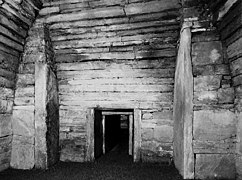
Access view (south) - circa 1970

Runic inscriptions in standard form and as branch runes

Drawing of Maes Howe Dragon from a photo


Digs
The modern opening of the Maeshowe Tumulus took place in 1861 by the antiquarian James Farrer. He managed the clearing of rubble and the initial recording of the runic inscriptions . The excavations of Vere Gordon Childe (1892–1957) in the 1950s, which were mainly aimed at securing the structural substance and the hill, confirmed that the hill above the chamber is not made of a mighty stone pack of rubble, as is the case with many northern Scottish cairns , but mainly consisted of clay and peat with broken stones interspersed. In the 1970s Colin Renfrew (born 1937) carried out several excavations with the aim of extracting datable material from the area of the leveled slab and from the trenches. In 2003, extensive technical investigations were carried out, in particular to get the condensation problem under control. The interior was measured photogrammetrically ; the results have not yet been fully published.
construction
The chamber construction is of great precision. The complex is built from flat, layered sandstones and has relatively flat walls on the inside. An approximately 11.0 m long, low, square corridor leads to the main chamber with the three side chambers. The entrances to the side chambers are not at floor level, but are less than a meter above in the walls. They could be closed by the stone blocks that were found on the chamber floor in front of the niches.
Sandstones from the region that were broken along natural weathering lines were used throughout. The exact position of the layer packages suggests that the surface of individual panels was reworked so that they could be layered as dry masonry with the narrowest possible joints . Concrete traces of processing have not yet been identified. The four stones worked into the corner pillars of the main chamber and two more in the passage (one as a wall in the west wall, one as a capstone) are among the largest single stones that were built into Scottish megalithic systems. The high main chamber was closed by a cantilever vault (now a concrete ceiling), while the niches have flat ceilings.
Access is aimed at the point when the sun sets on the day of the winter solstice. At the exit of the access passage there is a niche into which the locking stone could be pushed when opening (where it is now permanently). When closed, a gap of light remained free so that the sun's rays could fall into the chamber at sunset (similar to Newgrange through the so-called roof box ) and hit the niche in the wall opposite the entrance.
The hill above the plant is about seven meters high and about 35 meters in diameter. Renfrew's last digs showed that the shallow trench was probably the last to be made and never completed; so it presents itself especially in the northwest quadrant as the edge of the platform, which is bounded on the outside by a flat earth wall, most likely from the Viking Age .
Dating
No 14 C data are available for the grave itself . The material recovered from the grounds during Renfrew's excavations in the 1970s indicates times between 3930 BC. Chr. +/- 110 (Lab.No.SRR 791 from the northern trench section) and around 2110 BC Chr. ± 110 (Lab. No. SRR 504 from the southern trench section). After assessing the exact find positions, storage conditions and other 14 C data and their find positions as well as in comparison with structural findings in other graves of the type, he concludes that the complex was between 3,200 and 2,900 BC. Was built.
The runic inscriptions
The runic inscriptions in Maes Howe, which were mainly created in connection with the incursion of a group of crusaders about 1134-35, which is handed down in the Orkneyinga saga , are important for a number of reasons:
- It is the largest collection of runic inscriptions in situ that has been found to date.
- Your messages go far beyond the usual formulaic notes.
- They represent all three previously known rune spellings: normal script, twig runes and the tree-shaped style (tree runes); the deciphering of the latter was only possible through this discovery.
- On the one hand, they prove the close cultural-historical interdependencies in the North Atlantic area, on the one hand they prove - even if only in an apparently unimportant detail - how precise the traditions of the saga literature can be, and on the other hand they shed a completely new light on the position of women at that time ( e.g. the runic, here also writing Lifolf as a member of the crusader group).
The invading Vikings found something in Maes Howe that they considered a great treasure and which it took them several days to recover. What they found is unclear.
In addition to the inscriptions, three incised drawings of the Vikings have been preserved: One is interpreted as a walrus , the second shows a dog's head with a tongue hanging out, the third is the so-called Maeshowe dragon , a very differentiated representation of a dragon with a sword in its back . As one of the best-selling motifs of Orkney's thriving jewelry industry, the Maes Howe's dragon became a real treasure for the orcadians of today.
It is interesting to note that the early Norwegian settlers on Orkney called Maeshowe "Orkahaugr" (Ork Hill), possibly due to the residents' proper names or tribal names.
Web links
- The website of the Orcadian photographer Dr. Charles Tait shows the sunset from three camera positions every year from around the end of October to the end of January / mid-February. It also offers numerous stills for the Maeshowe and detailed descriptions of the property (English).
- Map with distribution of the type
See also
literature
- Patrick Ashmore: Maes Howe (= Historic Scotland. ). Reprinted edition. HMSO, Edinburgh 1997, ISBN 1-900168-06-5 .
- Frances Lynch: Megalithic tombs and Long Barrows in Britain (= Shire Archeology. 73). Shire Publications, Princes Risborough 1997, ISBN 0-7478-0341-2 .
- Michael P. Barnes: The Runic Inscriptions of Maeshowe, Orkney (= Runrön. 8). Institutions för Nordiska Språk - Uppsala Universitet, Uppsala, 1994, ISBN 91-506-1042-2 .
Coordinates: 58 ° 59 ′ 47.9 " N , 3 ° 11 ′ 17.8" W.