
Mai-Ndombe (Province)
| Mai-Ndombe | |
|---|---|
 _-_Mai-Ndombe.svg) |
|
| country |
|
| Provincial capital | Inongo |
| National language | Lingala |
| surface | 127,465 km² |
| population | 1,852,000 (2015) |
| Population density | 14.6 |
| ISO 3166-2 | CD-MN |
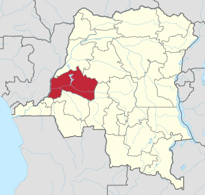
Mai-Ndombe (or in German Schwarzwasser ) is a province of the Democratic Republic of the Congo . The capital is Inongo .
geography

Mai-Ndombe is located in the west of the country and borders in the north with Equateur , in the northeast with Tshuapa , in the east with Kasaï , in the south with Kwilu and in the southwest with Kinshasa . In the west, the Congo River forms the border with the Republic of the Congo .
history
As early as 1963–1966 there was a province of the same name and of the same size (time of the so-called Provincettes ). During the renewed centralization, the provinces of Kwilu, Kwango and Mai-Ndombe were merged as districts to form the province of Bandundu .
According to the administrative reallocation of the country, which was provided for in the constitution of 2005, the province of Bandundu was to be divided up and Kwilu to receive provincial status and, as one of 26 provinces, to have its own administration and its own regional parliament. In January 2011, this reform was canceled by President Joseph Kabila through a controversial constitutional amendment . However, the reorganization was implemented in 2015 and Mai-Ndombe was given province status again.
Bas-Uele | Skin katanga | Haut-Lomami | Haut-Uele | Ituri | Kasaï | Kasaï-Central | Kasaï-Oriental | Congo Central | Kwango | Kwilu | Lomami | Lualaba | Mai-Ndombe | Maniema | Mongala | North Kivu | North Ubangi | Sankuru | Sud-Kivu | Sud-Ubangi | Tanganyika | Tshopo | Tshuapa | Equateur | Kinshasa (Capital District)