
Haut-Uele
| Haut-Uele | |
|---|---|
 _-_Haut-Uele.svg) |
|
| country |
|
| Provincial capital | Isiro |
| National language | Lingala |
| surface | 89,683 km² |
| population | 1,864,000 (2015) |
| Population density | 20.8 |
| ISO 3166-2 | CD-HU |
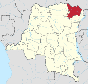
Haut-Uele (German Ober- Uelle ) is a province in the Democratic Republic of the Congo with around 1,864,000 inhabitants. The capital is Isiro (formerly Paulis).
geography
The province is located in the northeast of the country and is bordered by the Central African Republic in the northwest , South Sudan in the north, Ituri in the east and south , Tshopo in the southwest and Bas-Uele in the west .
history
The present-day province of Haut-Uele has belonged to the Orientale province since the Belgian colonial era . From 1933 to 1947 it was called Stanleyville (French) or Stanleystad (Dutch) (today's Kisangani ) after its capital . In 1962, Orientale was dissolved and divided into the provinces of Haut-Congo (Upper Congo), Kibali-Ituri and Uele. Four years later (1966) the province was restored and renamed Haut-Zaïre (Upper Zaire) in 1971. With the end of the rule of Mobutu Sese Seko in 1997, the province was renamed like the Republic of Zaïre. First again in Haut-Congo and within the same year it was given the name Orientale. According to the administrative reallocation of the country in the new constitution of 2005, Orientale should be divided into four provinces. However, the administrative reform was postponed several times and canceled in 2011, finally implemented in 2015 and thus elevated Haut-Uele to a province.
Bas-Uele | Skin katanga | Haut-Lomami | Haut-Uele | Ituri | Kasaï | Kasaï-Central | Kasaï-Oriental | Congo Central | Kwango | Kwilu | Lomami | Lualaba | Mai-Ndombe | Maniema | Mongala | North Kivu | North Ubangi | Sankuru | Sud-Kivu | Sud-Ubangi | Tanganyika | Tshopo | Tshuapa | Equateur | Kinshasa (Capital District)