
Mongala
| Mongala | |
|---|---|
 _-_Mongala.svg) |
|
| country |
|
| Provincial capital | Lisala |
| National language | Lingála |
| surface | 58,141 km² |
| population | 1,740,000 (2015) |
| Population density | 29.9 |
| ISO 3166-2 | CD-MO |
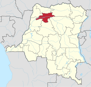
Mongala is a province of the Democratic Republic of the Congo . The capital of Mongalas is Lisala with 79,235 inhabitants (2010), but the city of Bumba is the largest city in the province with 103,328 inhabitants. The population of the entire provincial area was 1,740,000 in 2015.
geography
Mongala is located in the north-west of the country and borders in the north with north Ubangi , in the north-east with Bas-Uele , in the south-east with Tshopo , in the south with Tshuapa , in the south-west with Équateur and in the north-west with Sud-Ubangi .
Districts
The province is divided into three districts, all of which are named after their respective main towns:
- Bongandanga
- Bumba
- Lisala
history
Mongala was a district of the Equateur Province . According to the administrative reform announced in 2005 and canceled in 2011, Equateur was to be divided into five new provinces, including Mongala. The administrative reform was postponed several times and canceled in 2011, but finally implemented in 2015 and thus made Mongala a province.
Individual evidence
- ↑ Population of the largest towns in the DR Congo . World Gazetteer. Retrieved August 22, 2010.
- ^ Congo (Dem. Rep.): Provinces & Cities - Population Statistics, Maps, Charts, Weather and Web Information. Retrieved April 6, 2018 .
- ↑ http://www.ucdp-info.com/presses_secu_al.htm
Bas-Uele | Skin katanga | Haut-Lomami | Haut-Uele | Ituri | Kasaï | Kasaï-Central | Kasaï-Oriental | Congo Central | Kwango | Kwilu | Lomami | Lualaba | Mai-Ndombe | Maniema | Mongala | North Kivu | North Ubangi | Sankuru | Sud-Kivu | Sud-Ubangi | Tanganyika | Tshopo | Tshuapa | Equateur | Kinshasa (Capital District)