
North Ubangi
| North Ubangi | |
|---|---|
 _-_Nord-Ubangi.svg) |
|
| country |
|
| Provincial capital | Gbadolite |
| National language | Lingala |
| surface | 56,644 km² |
| population | 1,269,000 (2015) |
| Population density | 22.4 |
| ISO 3166-2 | CD-NU |
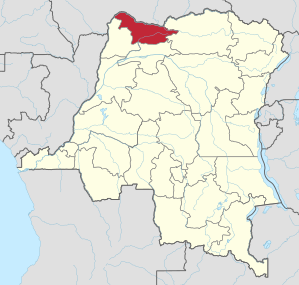
North Ubangi is a province in the Democratic Republic of the Congo . The capital is Gbadolite , the population of the provincial area was 1,269,000 in 2015.
geography
North Ubangi is located in the north of the country and borders on the Central African Republic in the north, Bas-Uele in the east, Mongala in the south and Sud-Ubangi in the southwest .
Districts
The province is divided into six districts, all of which are named after their respective main towns:
- Gbadolite
- Bosobolo
- Businga
- Mobayi-Mbongo
- Yakoma
history
Today's North Ubangi Province was a district of the former Équateur Province . According to the administrative reform announced in 2005 and canceled in 2011, Equateur was to be divided into five new provinces, including northern Ubangi. The administrative reform was postponed several times and canceled in 2011, but finally implemented in 2015 and thus elevated northern Ubangi to a province.
Individual evidence
- ^ Congo (Dem. Rep.): Provinces & Cities - Population Statistics, Maps, Charts, Weather and Web Information. Retrieved April 6, 2018 .
- ↑ http://www.ucdp-info.com/presses_secu_al.htm
- ↑ Tout savoir sur la province du Nord-Ubangi ( French )
Bas-Uele | Skin katanga | Haut-Lomami | Haut-Uele | Ituri | Kasaï | Kasaï-Central | Kasaï-Oriental | Congo Central | Kwango | Kwilu | Lomami | Lualaba | Mai-Ndombe | Maniema | Mongala | North Kivu | North Ubangi | Sankuru | Sud-Kivu | Sud-Ubangi | Tanganyika | Tshopo | Tshuapa | Equateur | Kinshasa (Capital District)