Maker-with-Rame
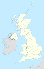
Location of Maker-with-Rame |
Maker-with-Rame is a civil parish in south east Cornwall in Great Britain . The parish is at the southeast end of the Rame Peninsula , about 6.5 km south of Saltash and 3 km west of Plymouth . The 525 hectare parish is bordered by the Hamoaze to the north, the Plymouth Sound to the east and the English Channel to the south . To the west it borders the parishes of Millbrook and St John .
history
Maker-with-Rame was created in 1941 by merging the two parishes Maker and Rame . The community consists of the five districts Maker, Rame, Cremyll , Cawsand and Kingsand . Over 90% of the 1070 residents live in the villages of Cawsand and Kingsand. Much of the parish is within Mount Edgcumbe Country Park .
In the course of the construction of the fort belt around Plymouth , numerous coastal fortifications were built along the coast in the 19th century , including the Cawsand Battery above Kingsand and Cawsand, Fort Picklecombe north of Kingsand, the Penlee Point Battery south of Cawsand and Polhawn Fort southwest of Rame. In addition, there were a total of five further coastal artillery positions at Maker, most of which, however, have disappeared again.
Maker
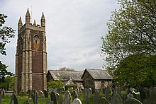
The church of the small hamlet Maker was first mentioned in 1186 and is dedicated to St Mary and St Julian . In the Middle Ages it was owned by the Priore of Plympton . In the 15th century it was enlarged to its present size. The church served as a family church and burial place for the Edgcumbe family. During the English Civil War , the church was fortified by Colonel Piers Edgcumbe until he had to surrender to Parliament in 1644. Inside there is a Romanesque baptismal font. In the 18th and 19th centuries, the church tower served as a signal station for the Royal Navy . Is on the road to a Cremyll St Julian consecrated holy spring with a small chapel dating from the 14th or 15th century.
Rame
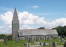
The district of Rame consists of only a few houses and the church of St Germanus. Rame is first mentioned in 981 when Count Ordulf , an uncle of Æthelred , gave Rame to the Tavistock Abbey, which he founded . In the Domesday Book of 1086, Rame is mentioned as being owned by Tavistock. The church, made of slate, dates from 1239 and was consecrated to St Germanus in 1259 . In the 15th century the church was rebuilt and expanded. It is one of the few churches in Cornwall to have a steeple that served as a navigation mark for entry into Plymouth Sound. The church was restored in 1848 and 1886. Inside it still has rows of banks from the 16th century, it is still not connected to the power grid and has to be lit with candles.
South of Rame is the headland of Rame Head .
Cremyll
The small ferry town of Cremyll is the end point of the passenger ferry coming from Stonehouse , a district of Plymouth. Until the opening of the ferry between Devonport and Torpoint in 1791, the ferry was the main route between Plymouth and south east Cornwall. It was mentioned as early as 1204, but is probably even older. In the Middle Ages, a village called West Stonehouse existed in place of the current settlement , while the settlement on the east bank of the Hamaoze was called East Stonehouse . In 1350 West Stonehouse was burned down by the French. When the village was rebuilt it was named Cremyll.
Cremyll is the main driveway to Mount Edgcumbe House .
Cawsand and Kingsand
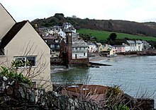
Cawsand and Kingsand are two twin villages on Cawsand Bay. Until 1844 the two villages were separated, Cawsand belonged to the parish of Rame and Cornwall, Kingsand belonged to Maker and Devon . The border between the two counties was formed by a stream that is now built over. Since a border correction carried out in 1844, both villages have belonged to Cornwall.
Since Cawsand belonged to Rame until 1941 and the church of Rame is very far from the village, the church of St Andrew's in Cawsand was built in 1878 .
Cawsand Bay is a natural harbor with two beaches at Kingsand and Cawsand. The name Cawsand is first mentioned as Couyssond at the beginning of the 15th century . In earlier centuries the population of the two villages lived from fishing and especially in the 18th and 19th centuries from smuggling. Today the two villages are popular excursion destinations, around a third of the houses are used as holiday homes or second homes.
South of Cawsand is the penlee point headland .
literature
- Maker-with-Rame Parish Plan, Parish Council (2004)
Web links
Individual evidence
- ↑ GENUKI: Maker. (No longer available online.) Archived from the original on October 17, 2012 ; Retrieved April 2, 2013 . Info: The archive link was inserted automatically and has not yet been checked. Please check the original and archive link according to the instructions and then remove this notice.
- ↑ Plymouth South Western Defecences. Retrieved April 2, 2013 .
- ^ Rame History Group: The Signal Tower, Maker Heights, Rame Peninsula. (PDF; 234.9 kB) Retrieved April 3, 2013 .
- ^ The National Heritage List for England: St Julian's Well. (No longer available online.) Formerly in the original ; Retrieved April 3, 2013 . ( Page no longer available , search in web archives ) Info: The link was automatically marked as defective. Please check the link according to the instructions and then remove this notice.
- ^ Mount Edgcumbe Country Park. Retrieved March 31, 2013 .
- ^ Cremyll Ferry History. (No longer available online.) Archived from the original on February 4, 2013 ; Retrieved April 2, 2013 . Info: The archive link was inserted automatically and has not yet been checked. Please check the original and archive link according to the instructions and then remove this notice.
- ^ The Encyclopaedia of Plymouth History: Plymouth, a history. Retrieved June 30, 2013 .
- ^ Church of England: Maker, St Mary & St Julian. Retrieved April 2, 2013 .
Coordinates: 50 ° 21 ′ N , 4 ° 11 ′ W


