Manitoba Highway 75
| Provincial Trunk Highway 75 in Manitoba, Canada | ||||||||||||||||||||||||||||||||||||||||||||||||||||
| Lord Selkirk Highway | ||||||||||||||||||||||||||||||||||||||||||||||||||||

|
||||||||||||||||||||||||||||||||||||||||||||||||||||
| Basic data | ||||||||||||||||||||||||||||||||||||||||||||||||||||
| Operator: | Manitoba Infrastructure and Transportation |
|||||||||||||||||||||||||||||||||||||||||||||||||||
| Start of the street: |
Winnipeg ( 49 ° 47 ′ N , 97 ° 9 ′ W ) |
|||||||||||||||||||||||||||||||||||||||||||||||||||
| End of street: |
Emerson ( 49 ° 0 ′ N , 97 ° 14 ′ W ) |
|||||||||||||||||||||||||||||||||||||||||||||||||||
| Overall length: | 94 km | |||||||||||||||||||||||||||||||||||||||||||||||||||
|
Region : |
|
|||||||||||||||||||||||||||||||||||||||||||||||||||
|
Course of the road
|
||||||||||||||||||||||||||||||||||||||||||||||||||||
The Manitoba Highway 75 (PTH 75), also known as Lord Selkirk Highway, is located in the Canadian province of Manitoba , he has km in length one hundred and first The highway begins south of Winnipeg on the Perimeter Highway ( Highway 100 ) and ends at the border with the United States . As a core route, the route is part of the National Highway System .
Routing
The route begins on Highway 100, also known as the Perimeter Highway, which forms the southern part of the city ring around Winnipeg. To the north, the route leads into the city center as Route 42, while Highway 75 itself leads south along the Red River , which lies along the entire route east of the highway. This location has caused the street to be flooded in the past, with the area near Morris being the hardest hit. To reduce the flooding in Morris, the city was to be diked , in the course of which new bridges were built for the highway, so that the route can be carried out at a higher level.

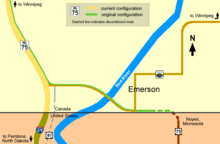
The highway ends at the border with the United States and has continued into the state of North Dakota since it opened as Interstate 29 to Grand Forks . Before this was built, there was a connection to US Route 75 , which is then already in Minnesota , but this route has now been closed.
Individual evidence
- ↑ Lord Selkirk Highway. Government of Canada - Geographical Names, accessed June 22, 2017 .
- ^ National Highway System - An Overview. (PDF; 146.21 kB) (No longer available online.) Council of Ministers - Responsible for Transportation and Highway Safety, April 2008, archived from the original on June 29, 2016 ; accessed on October 6, 2016 . Info: The archive link was inserted automatically and has not yet been checked. Please check the original and archive link according to the instructions and then remove this notice.
- ↑ Manitoba government announces plans to raise PTH 75, rebuild two bridges near Morris. November 21, 2014, accessed June 22, 2017 .