Manukau Harbor
| Manukau Harbor | ||
| Geographical location | ||
|
|
||
| Coordinates | 37 ° 2 ′ S , 174 ° 43 ′ E | |
| Region ISO | NZ-AUK | |
| country | New Zealand | |
| region | Auckland | |
| Sea access | Tasman Sea | |
| Data on the natural harbor | ||
| Port entrance | 2 178 m wide | |
| length | around 38 km | |
| width | Max. 22 km | |
| surface | 365 km 2 | |
| Coastline | around 195 km | |
| Water depth | Max. 50 m | |
| Water depth | 4.5 m on average | |
| places | Auckland | |
| Tributaries | Waiuku River | |
| Islands | Puketutu Island , Wiroa Island , (both artificially connected to the mainland) | |
| Industrial port | kl. Port facility in the Onehunga district of Auckland | |
| Photography of the natural harbor | ||
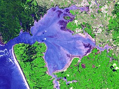
 Manukau Harbor satellite image from NASA |
||
The Manukau Harbor is a natural harbor on the west coast of the North Island of New Zealand . It is the second largest in the country.
geography
The Manukau Harbor is located west of the Isthmus of Auckland with an access to the Tasman Sea . The natural harbor, which belongs to the urban area of Auckland , covers an area of around 365 km 2 and with its tributaries drains an area of approximately 895 km 2 . Its coastline extends for around 195 km. During a spring tide , the entire harbor basin contains an estimated 221.5 million m 3 of water.
The 2.3 km wide entrance to Manukau Harbor is between the southern end of the Waitakere Ranges and the Manakau Heads opposite . From the port entrance, the water extends around 31 km to the east into the Mangere Inlet , which is part of the port basin and is surrounded by the districts of Onehunga , Te Papapa , Westfiled , Otahuhu and Mangere . Over the Papakura Channel into the Pahurehure Inlet in the southeast , which ends in the Papakura district , the water stretches over 38 km. The width of the harbor basin is around 22 km.
The greatest inflow comes from the Waiuku River coming from the south . The largest island in the natural harbor is Puketutu Island , which is of volcanic origin and connected to the mainland by a dam. Wiroa Island , the smaller of the two islands, is located on the southeastern edge of the grounds of Auckland Airport and is used by it.
The tidal range inside the port basin is between 1.5 m and 2.7 m and at the port entrance between 2.0 m and 3.4 m.
history
The small town of Cornwallis , located on the Puponga peninsula near the port entrance, was originally the place where Auckland was to be built. Because of fraudulent land sales and the fragmented landscape, this project was abandoned in the 1840s. The bush on the surrounding hills was once overgrown with numerous kauri trees . However, these were felled, processed in sawmills and shipped as lumber from Paratutai to the other end of Manukau Harbor near Onehunga for the houses in the new city of Auckland . Another part of the wood was shipped along the coast to other New Zealand settlements. The last sawmills were abandoned in the early 1920s.
Features of the port
Because of the large water surface of the harbor basin and the relatively narrow harbor entrance, the tidal current is strong and the shallow driveway makes navigation extremely difficult. The worst shipping accident in New Zealand occurred here in 1863 when the HMS Orpheus ran aground on a clear day and claimed 189 lives. For this reason and because of the shallow water, Manukau Harbor is not the preferred port in Auckland and the port facilities in Onehunga are not very large compared to the other facilities in Waitemata Harbor on the northeast side of the isthmus.
Recreational use
The harbor is a popular fishing spot, although access to the water via the few boat ramps that can be used in all tides is difficult, so the beaches are often used for this purpose.
See also
literature
- Environmental condition and values of Manukau Harbor . In: Auckland Regional Council (Ed.): Technical Report . No. 112 , 2009, ISBN 978-1-877540-27-1 (English, online [PDF; 5.5 MB ; accessed on April 17, 2017]).
Web links
- About Manukau Harbor . Auckland Council,accessed April 17, 2017.
Individual evidence
- ↑ Environmental condition and values of Manukau Harbor . 2009, p. 8 .
- ↑ The linear expansion and the coordinates were measured with Google Earth.
- ↑ Environmental condition and values of Manukau Harbor . 2009, p. 30 .
- ↑ The Dream That Was Cornwallis . Denise & Peter , 2001, accessed April 17, 2017 .

