Margarethenkreuz (Ittenbach)
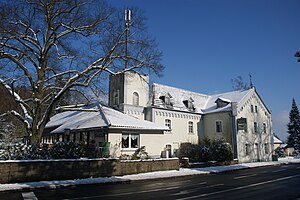
The Margarethenkreuz is a courtyard that serves as a restaurant on the Margarethenhöhe , a district of the town of Königswinter in the North Rhine-Westphalian Rhein-Sieg district that belongs to Ittenbach . The building was previously used as a hotel and is a listed building .
location
The building complex of the restaurant is located on the pass-like Margarethenhöhe ( 320 m above sea level ) on the north side of Landesstraße 331 opposite the Margarethenhof . There are several parking spaces for hikers to the north , which are located at the beginning of the ascent to the Great Mount of Olives .
history
The origin of the four-wing courtyard is a residential building that was built in 1844 on the grounds of the Margarethenkreuzhof estate . In 1843 it had eight residents. The house was already partially used as a restaurant and was expanded in 1861. In 1889 an almost 20 m long half-timbered building was built as a restaurant hall. In 1903 the name was changed to Margarethenkreuz . Hotel operations began in the manor buildings around 1909, while agriculture lost its importance. Additional structural extensions were made with increasing tourism in the Siebengebirge in the 1930s and again in the 1950s.
architecture
A two-story, plastered residential building on the street side belongs to the four-winged farm yard. In the west of the house there is a three-storey tower on a square floor plan with battlements . The decorative shapes of the building can be attributed to historicism and include segmented arched windows with shutters , corner pilasters and corner guards as well as round arched friezes . The entrance to the restaurant is embedded in a plane courtyard.
literature
- Angelika Schyma : City of Königswinter (= monument topography Federal Republic of Germany , monuments in the Rhineland , volume 23.5.). Rheinland-Verlag, Cologne 1992, ISBN 3-7927-1200-8 , p. 97.
Web links
- History of the inn
- Historical Views of the inn: Brückenhofmuseum virtual , virtual museum Ittenbach
References and comments
- ↑ Designation also in the German basic map
- ↑ Royal Government of Cologne: overview of the components u. Directory of all localities in the government district of Cologne. Cöln 1845, p. 87 .
- ↑ The entrance to the forest is Paul Bachem's legacy , General-Anzeiger , February 9, 2004
Coordinates: 50 ° 40 ′ 36.7 ″ N , 7 ° 14 ′ 58.5 ″ E
