
Maros (administrative district)
| Maros | ||
|---|---|---|
| Symbols | ||
|
||
| Basic data | ||
| Country | Indonesia | |
| province | Sulawesi Selatan | |
| Seat | Maros | |
| surface | 1,619.1 km² | |
| Residents | 250,000 (2005) | |
| density | 154 inhabitants per km² | |
| ISO 3166-2 | ID-SN | |
| Website | www.maroskab.go.id (Indonesian) | |
| politics | ||
| Bupati | Ir. HM Hatta Rahman, MM | |
 |
||

Coordinates: 5 ° 0 ′ S , 119 ° 35 ′ E
Maros is an Indonesian government district ( Kabupaten ) in the province of South Sulawesi . The administrative seat is the city of the same name Maros . The district has an area of 1619.12 km² and a population of around 250,000.
In the district there is also the Bantimurung-Bulusaraung National Park , whose waterfall is a popular destination for the local population. Karst caves in the Maros-Pangkep region .
Administrative division
The Maros district consists of 14 administrative districts ( Kecamatan ) (as of 2010):
| Surname | Population census 2010 |
|---|---|
| Mandai | 35,044 |
| Moncongloe | 16,939 |
| Maros Baru (Maros Town) |
23,987 |
| Marusu | 25,226 |
| Turikal | 41,319 |
| Lukewarm | 24,201 |
| Bontoa | 26,573 |
| Bantimurung | 28,078 |
| Simbang | 22,209 |
| Tanralili | 24,456 |
| Tompu Bulu | 14,104 |
| Camba | 12,554 |
| Cenrana | 13,593 |
| Mallawa | 10,719 |
12 of the 14 districts are within the official Makassar metropolitan area , only two - Camba and Mallawa - are outside.
Individual evidence
- ^ Biro Pusat Statistics, Jakarta, 2011.
history

Prehistoric wall paintings in the Pettakere cave

The ruler of Maros and his retinue
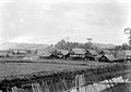
A village in Maros (1929)

"Benteng" fortress in Maros (1929)

Street view at Maros (1929)

A stream near Maros (1929)

A house in Maros (1929)


Web links

Administrative region:
Bantaeng |
Barru |
Bone |
Bulukumba |
Enrekang |
Gowa |
Jeneponto |
Luwu |
Maros |
North Luwu ( Luwu Utara ) |
North Toraja ( Toraja Utara ) |
East Luwu ( Luwu Timur ) |
Pangkajene and Islands ( Pangkajene dan Kepulauan ) |
Pinrang |
Salajar Islands ( Kepulauan Selayar ) |
Sidenreng Rappang |
Sinjai |
Soppeng |
Takalar |
Tana Toraja |
Wajo
City:
Makassar |
Palopo |
Pare-pare