Marysville (Kansas)
| Marysville | |
|---|---|
| Nickname : Black Squirrel City | |
 Water tower in Marysville |
|
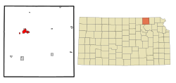
| Location in Kansas | |
| Basic data | |
| Foundation : | 1855 |
| State : | United States |
| State : | Kansas |
| County : | Marshall County |
| Coordinates : | 39 ° 51 ′ N , 96 ° 39 ′ W |
| Time zone : | Central ( UTC − 6 / −5 ) |
| Residents : | 3,271 (as of: 2000) |
| Population density : | 384.8 inhabitants per km 2 |
| Area : | 8.5 km 2 (approx. 3 mi 2 ) of which 8.5 km 2 (approx. 3 mi 2 ) is land |
| Height : | 354 m |
| Postcodes : | 66508, 66555 |
| Area code : | +1 785 |
| FIPS : | 20-45050 |
| GNIS ID : | 0472911 |
Marysville is a city in Kansas and the administrative seat of Marshall County .
etymology
Marysville was named after Mary Marshall, the wife of Francis J. Marshall. He opened the first post office in the Kansas Territory here on November 11, 1854 and installed a ferry service over the Big Blue River , which was in operation until 1864, the year a bridge was opened at the same location.
history
Marysville was on the Oregon Trail and the Mormon Trail and was a station on the Pony Express that is still there today.
traffic
Marysville is located at the intersection of US Highway 36 ( Pony Express Highway ) and US Highway 77 .
fauna
In Marysville there is an isolated population of a dark form of the gray squirrel , which is why Marysville is also called Black Squirrel City .
sons and daughters of the town
- Ralph Nelson Elliott (1871-1948), finance scientist
- Merrell Q. Sharpe (1888–1962), politician and governor of South Dakota
- Louis Thomas Hardin, called Moondog (1916–1999), composer and musician
- Michael McClure (1932-2020), poet, writer and playwright
- Kenneth W. Dam (* 1932), US Vice Secretary of State from 1982 to 1985
- Thomas James Olmsted (* 1947), clergyman and Roman Catholic Bishop of Phoenix
- Kendra Wecker (* 1982), basketball player
