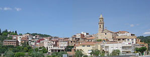
Maspujols
| Maspujols municipality | ||
|---|---|---|

|
||
| coat of arms | Map of Spain | |

|
|
|
| Basic data | ||
| Autonomous Community : | Catalonia | |
| Province : | Tarragona | |
| Comarca : | Baix Camp | |
| Coordinates | 41 ° 11 ' N , 1 ° 3' E | |
| Height : | 214 msnm | |
| Area : | 3.57 km² | |
| Residents : | 827 (Jan. 1, 2019) | |
| Population density : | 231.65 inhabitants / km² | |
| Postal code : | 43382 | |
| Municipality number ( INE ): | 43081 | |
| administration | ||
| Mayor : | Josep Rabascall Domingo | |
| Website : | www.maspujols.altanet.org | |
Maspujols is a municipality in Catalonia . It is located in the Comarca Baix Camp in the province of Tarragona .
geography
Maspujols is located about 3.5 km northwest of Reus on the Riera de Riudoms river on the southwestern edge of the Muntanyes de Prades . The municipality consists of the districts Maspujols and Rocabruna.
history
The place was first mentioned in 1172 in a gift certificate from Alfonso II of Aragón . The King of Aragon donated land around Rocabruna to Berenguer d'Oms . In 1303 another document mentions the Can Pujols farm in the municipality of Aleixar . In 1625, after a decision by the Dukes of Cardona , the town became independent.
economy
The economy of the region and the municipality is characterized by agriculture. The place is surrounded by hazelnut and olive tree plantations.
Web links
- Community website
- Maspujols at the Gran Enciclopèdia Catalana
Individual evidence
- ↑ Cifras oficiales de población resultantes de la revisión del Padrón municipal a 1 de enero . Population statistics from the Instituto Nacional de Estadística (population update).
