Matamata (New Zealand)
| Matamata | ||
| Geographical location | ||
|
|
||
| Coordinates | 37 ° 49 ′ S , 175 ° 46 ′ E | |
| Region ISO | NZ-WKO | |
| Country |
|
|
| region | Waikato | |
| District | Matamata-Piako District | |
| Ward | Matamata Ward | |
| Residents | 7th 089 (2013) | |
| height | 63 m | |
| Post Code | 3400 | |
| Telephone code | +64 (0) 7 | |
| UN / LOCODE | NZ MTA | |
| Photography of the place | ||
 Matamata entrance sign |
||
Matamata is a small rural town in the Matamata-Piako District of the Waikato regionon the North Island of New Zealand .
Origin of name
Matamata is the term for "headland" in the Māori language . Matamata was the name of the village ( Pā ) of the Māori chief Te Waharoa , which was built on a headland protruding from the marshland.
geography
The city is located around 28 km northeast of Cambridge and around 19 km north of Tirau , in the plain of the two rivers Waitoa River and Waihou River . The mountain ranges of the Kaimai Range rise around 10 km east of the city.
history
The area around Matamata was the tribal area of Te Waharoa , Māori chief of the Ngati Haua . Te Waharoa s son, Wiremu Tamihana Tarapipi , was one of the opponents of the signing of the Treaty of Waitangi in 1840 and was later one of the strongest supporters of the Kīngitanga ( Māori King Movement ).
In 1865 the settler and landowner Josiah Clifton Firth purchased a piece of land from Wiremu Tamihana Tarapipi . He had wetlands drained, roads built, straightened 80 kilometers of the Waihou River and introduced numerous machines for harvesting grain, making wine and preserving milk. In 1884, his farm was around 23,000 hectares in size. In 1888 his speculation and a general drop in the price of agricultural products forced him to sell his property. The settlement of Matamata was finally founded on the grounds of his former farm and grew so rapidly in the following years that it was given city status in 1935.
population
In the 2013 census, the town had 7,089 inhabitants, 12.4% more than in the 2006 census.
economy
The region around Matamata is known for breeding thoroughbred horses .
Education
Matamata has a state primary school , a Christian primary school , an intermediate school and a college . The Matamata - College has about 800 students, mostly farmers and children from the area. Casey Williams , a well-known netball player, is a former high school student. The college has many international exchange students.
tourism
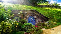
A farm outside the city was used as a filming location for the trilogy The Lord of the Rings as "Hobbiton" in the "Shire". The area with the dwellings has been a tourist attraction since it was filmed. Another popular tourist destination is the Opal Hot Springs , 8 km northeast of Matamata .
Sports
The city offers the opportunity for many recreational activities such as horse riding, swimming, squash, golf and fishing.
sons and daughters of the town
- Greg Davis (1939–1979), Australian rugby player and team captain of the Australian National Rugby Union Team
See also
literature
- Helga Neubauer: Matamata . In: The New Zealand Book . 1st edition. NZ Visitor Publications , Nelson 2003, ISBN 1-877339-00-8 , pp. 263 f .
Web links
Individual evidence
-
↑ a b
Population of Matamata :
- 2013 Census QuickStats about a place : Matamata North . Statistics New Zealand,accessed August 8, 2017.
- 2013 Census QuickStats about a place : Matamata North . Statistics New Zealand,accessed August 8, 2017.
- ↑ a b Matamata . In: The New Zealand Book . 2003, p. 264 .
- ↑ Topo250 maps . Land Information New Zealand , accessed August 8, 2017 .

