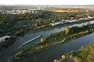
Lower Neckar: Mulberry Island
|
Nature reserve "Lower Neckar: Mulberry Island"
|
||
| location | Mannheim district in Baden-Wuerttemberg , Germany | |
| surface | 10.6 ha | |
| Identifier | 2102 | |
| WDPA ID | 166009 | |
| Geographical location | 49 ° 29 ' N , 8 ° 30' E | |
|
|
||
| Setup date | 17th December 1986 | |
| administration | Karlsruhe Regional Council | |
The Mulberry Island was created around 1930 when the Neckar Canal was being built . It lies between this and the Alt Neckar in the Mannheim district. The western part of the island is designated as a nature reserve.
It is part of the “Lower Neckar” nature and landscape protection area, which is divided into six protected areas from Heidelberg to Mannheim. The Neckar is characterized here by a strong agro-cultural and technical-industrial use and change. The purpose of the protection is to preserve and promote the fauna and flora typical of the river and, on the Mulberry Island, in particular to secure the remnants of a plantation of the white mulberry tree ( Morus alba ) established at the beginning of the 19th century . It was created by Grand Duchess Stephanie von Baden , who wanted to revive silkworm breeding ( Bombyx mori ), which had been promoted by the Palatinate electors since 1690 . The 10.3 hectare nature reserve was designated in 1986.
See also
literature
- Thomas Breunig, Siegfried Demuth: Naturführer Mannheim , Verlag Regionalkultur 2000, ISBN 978-3-89735-132-5 , p. 85/86
- District Office for Nature Conservation and Landscape Management Karlsruhe (Ed.): The nature reserves in the administrative district of Karlsruhe . Thorbecke, Stuttgart 2000, ISBN 3-7995-5172-7 , pp. 609-610
Web links
- Profile of the nature reserve in the LUBW's list of protected areas


