
Meineweh (Meineweh)
|
My pain
community Meineweh
|
|
|---|---|
 |
|
| Height : | 259 m |
| Area : | 15.79 km² |
| Residents : | 627 (Dec. 31, 2008) |
| Population density : | 40 inhabitants / km² |
| Incorporation : | January 1, 2010 |
| Postal code : | 06721 |
| Area code : | 034425 |
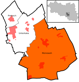  Location of Meineweh in Meineweh
|
|
Meineweh is a district of the community of Meineweh in the Burgenlandkreis in Saxony-Anhalt .
geography
Meineweh is about 14 km southeast of Naumburg (Saale) am Maibach. Thierbach, Quesnitz and Priesen are identified as districts of the municipality.
history
Meineweh was first mentioned in a document in 1171.
Meineweh was hit by witch hunts in 1649 . Paul Hoffmann got into a witch trial .
On January 1, 2010, the previously independent communities of Meineweh, Pretzsch and Unterkaka merged to form the new community of Anhalt Süd, which was renamed Meineweh on August 1, 2011.
badges and flags
The coat of arms was approved on March 23, 2000 by the Halle regional council.
Blazon : "In gold between two oblique blue wavy bars pushed apart, four rising green leaves (poplar, oak, linden, ginkgo biloba)."
The colors of the former municipality - derived from the coat of arms - are blue and yellow.
The flag of the former municipality of Meineweh shows the colors of the municipality: blue-yellow.
Culture and sights

The Meineweher parish church was in the 14./15. It was built in the late Gothic style in the 17th century.
Economy and Infrastructure
The federal road 180 which runs from Naumburg (Saale) to Zeitz leads directly through the community. It is approx. 3 km to the Naumburg junction on the federal motorway 9 .
Individual evidence
- ^ Manfred Wilde: The sorcery and witch trials in Kursachsen , Cologne, Weimar, Vienna 2003, pp. 625–627.
- ↑ StBA: Area changes from January 01 to December 31, 2010