Mersing (river)
| Mersing | ||
|
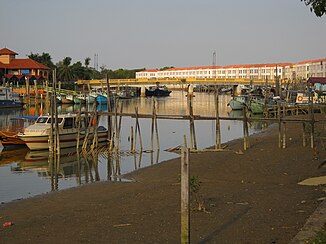
The Mersing in the village of Mersing |
||
| Data | ||
| location | Malaysia | |
| River system | Mersing | |
| muzzle | in the South China Sea Coordinates: 2 ° 26 ′ 9 ″ N , 103 ° 50 ′ 25 ″ E 2 ° 26 ′ 9 ″ N , 103 ° 50 ′ 25 ″ E |
|
| Mouth height |
0 m
|
|
| length | 20 km | |
| Catchment area | 270 km² | |
| Left tributaries | Sungai Mayang | |
| Medium-sized cities | Mersing | |
The Mersing ( Malay Sungai Mersing ) is a small river about 20 km in length in the south-east of the Malay Peninsula in the state of Johor near the border to Pahang . The river flows from south to north and flows into the South China Sea at Mersing . The estuary serves as a port for fishing and ferry operations to the offshore islands. However, the river bed is so shallow that the ferry timetables have to be adapted to the tides.
Individual evidence
- ↑ - ( Memento of the original from July 21, 2011 in the Internet Archive ) Info: The archive link was inserted automatically and has not yet been checked. Please check the original and archive link according to the instructions and then remove this notice.
