Merzbach (Moselle)
| Merzbach | ||
|
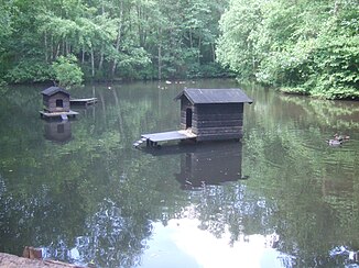
Biotope on the Merzbach |
||
| Data | ||
| Water code | DE : 26714 | |
| location | Rhineland-Palatinate , Germany | |
| River system | Rhine | |
| Drain over | Moselle → Rhine → North Sea | |
| source | in the Meulenwald near Schweich | |
| Source height | approx. 303 m above sea level NHN | |
| muzzle | In Issel in the Moselle Coordinates: 49 ° 49 ′ 6 ″ N , 6 ° 43 ′ 59 ″ E 49 ° 49 ′ 6 ″ N , 6 ° 43 ′ 59 ″ E |
|
| Mouth height | approx. 123 m above sea level NHN | |
| Height difference | approx. 180 m | |
| Bottom slope | approx. 45 ‰ | |
| length | 4 km | |
| Catchment area | 3.91 km² | |
| Small towns | Keep quiet | |
The Merzbach is a brook in the area of the town of Schweich in the district of Trier-Saarburg in Rhineland-Palatinate , which flows from the left into the middle Moselle in the district of Issel after a 4 km long, somewhat winding, but overall southern course .
course
The Merzbach crosses three landscapes on its course. It arises in the eastern Meulenwald at an altitude of about 303 m above sea level. NHN , digs a notch valley in the forest, in which it flows under the Schweicher Heilbrunnen on the right slope. A little later he steps out of the forest into the open Föhrener Kuppenland , where he passes under the L 47 in front of Schweich's first houses. Its lower course belongs to the Trier Moselle valley . Finally, it crosses Issel there and flows into the middle Moselle from the left a little below Moselle kilometer 180.
Catchment area
The Merzbach is 4.0 km long and has a catchment area of 3.9 km², which lies between those of the more important streams Quintbach in the west and Föhrenbach in the east and north. On the lower half of the course, that of the Föhrenbach is pushed to the east in front of that of the much smaller Ermesgraben .
See also
Individual evidence
- ↑ Map service of the landscape information system of the Rhineland-Palatinate nature conservation administration (LANIS map) ( notes )
- ↑ a b GeoExplorer of the Rhineland-Palatinate Water Management Authority ( information )
