Tarawa Military Air Base
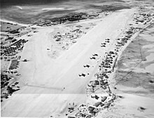
The Tarawa military airfield on the southwestern island of Betio of today's Kiribati- Atoll Tarawa was a military facility built in 1942 under the direction of Rear Admiral Tomanari Saichirō ( 友 成 佐 市 郎 ). Tarawa is an atoll in the Central Pacific that was fortified by the Japanese occupiers during World War II . The military facilities also include the airfield in the middle of the atoll.
construction
In September 1942, Rear Admiral Tomanari came with a ship convoy to Betio, the main island on the southwestern tip of the Tarawa Atoll with the only seaport. He was commissioned by the Supreme Imperial Naval Staff to fortify the island, as an American landing was feared. In addition to the admiral's staff, the ship convoy also transported around 4,000 soldiers from various regiments and battalions as well as 500 Korean auxiliary soldiers. Tomanari ordered an airfield to be built in the middle of the island so that it could be protected against enemy air attacks by the Japanese naval air force . Work began immediately, and in October 1942 four concrete runways were completed (length 1,213 m), between which there were about 400 barracks , administrative offices and shelters . The hangars were partly made of cement and partly covered with corrugated iron . The air base could accommodate up to 50 aircraft.
Strategic importance
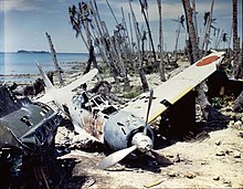
In November 1942, the Imperial Japanese Navy Air Force immediately flew in 26 Mitsubishi A6M Zero fighters to defend Betio Island. In December, 20 seaplanes arrived , which were lying in the shallow lagoon water in front of the dock , and were supposed to serve for reconnaissance .
The airfield, renamed Hawkins Field by the Marines after the conquest of Tarawa in 1943 , was strategically important for both sides: the Japanese army used it as a flexible base whose aircraft could oversee the entire central Pacific. After the American attack on the great Japanese port of Truk , the planes stationed on Betio were able to cover this sector in the event of a new American air raid. They were also able to fly strategic reconnaissance around the Gilbert and Marshall Islands .
For Americans Hawkins Field was important because its own aircraft in case of a conquest of the Marshall and Mariana Islands , air support could afford. In addition, the squadrons were able to locate and attack all Japanese air and sea traffic .
The Japanese army therefore did everything in its power to defend the Tarawa airfield. She kept flying in fresh planes, even though the island was under heavy air fire in early 1943. USAAF's air strikes were intended to weaken Japanese fortifications and the airfield. But as soon as Betio had lost all of their aircraft, the Imperial Army flew in new ones that fought against the American F6F Hellcats and F4U Corsairs .
However, all aircraft were shot down or devastated during the American air strikes preparing the Marines to land on the atoll. American losses over the ten-month airstrike amounted to 346 fighters and bombers (shot down or badly damaged) and 23 seaplanes (shot down). The Japanese lost 513 aircraft.
Operation Galvanic , the cover name of the entire company for the capture of the Gilbert Islands, started on November 20, 1943. When the Americans landed, the island was without an air defense . However, the Japanese defenders had orders to defend the tarmac . On the first day of the battle the first line of fortification held, on the second it was breached and the marines took the airfield. The Japanese soldiers tried to force the GIs to retreat, but all of their counterattacks were thrown back.
literature
- Ugaki Matome : Fading Victory: The Diary of Admiral Matome Ugaki, 1941-1945. University of Pittsburgh Press, Pittsburgh 1991, ISBN 0-8229-5462-1 . New edition: Naval Institute Press, Annapolis 2008, ISBN 978-1-59114-324-6 (Editors: Katherine V. Dillon, Donald M. Goldstein, Gordon W. Prange. Translator: Masataka Chihaya).
- Bernard Millot: The Pacific War . BUR, Montreuil 1967
Web links
Coordinates: 1 ° 21 '22 " N , 172 ° 55' 48" E


