Mionica
| Мионица | |||
|
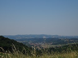
Panorama of Mionica |
|||
|
|||
| Basic data | |||
|---|---|---|---|
| State : | Serbia | ||
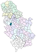
| Okrug : | Kolubara | ||
| Opština : | Opština Mionica | ||
| Coordinates : | 44 ° 15 ' N , 20 ° 5' E | ||
| Height : | 189 m. i. J. | ||
| Area : | 329 km² | ||
| Residents : | 1,620 (2011) | ||
| Agglomeration : | 16,513 (2011) | ||
| Population density : | 5 inhabitants per km² | ||
| Telephone code : | (+381) / (0) 14 | ||
| Postal code : | 14242 | ||
| License plate : | VA | ||
| Structure and administration | |||
| Community type: | Opština | ||
| Website : | |||
Mionica ( Serbian - Cyrillic Мионица ) is a village with a good 1500 inhabitants as the center of the approximately ten times larger municipality of the same name in the Kolubara district in Serbia .
geography
The town, founded in the mid-19th century, is located on the Kolubara , a tributary of the Sava just under kilometers south of Belgrade .
Economy and culture
Mionica is characterized by agricultural production, which employs around a third of the population, which is mainly of Serbian origin. A popular mineral water comes from the neighboring spa town of Vrujci .
The oldest building in the town is the church from 1856. A monument commemorates Živojin Mišić .
Town twinning
There is a municipal partnership with Tomaszów Mazowiecki in the Łódź Voivodeship in Poland.
Web links
- Homepage of the municipality of Mionica
Individual evidence
- ↑ Tomaszów Mazowiecki - oficjalna strona Urzędu Miasta. Retrieved April 17, 2020 .


