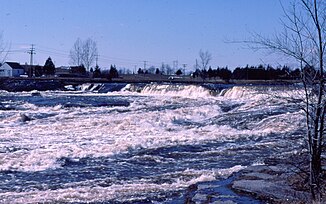
Moira River
| Moira River | ||
|
Moira River |
||
| Data | ||
| location | Hastings County in Ontario, Canada | |
| River system | Saint Lawrence River | |
| Drain over | Saint Lawrence River → Atlantic Ocean | |
| source | at Tudor and Cashel 44 ° 52 ′ 41 ″ N , 77 ° 32 ′ 13 ″ W. |
|
| Source height | 355 m | |
| muzzle | near Belleville in the Bay of Quinte (Lake Ontario) Coordinates: 44 ° 9 ′ 39 ″ N , 77 ° 23 ′ 3 ″ W, 44 ° 9 ′ 39 ″ N , 77 ° 23 ′ 3 ″ W |
|
| Mouth height | 75 m | |
| Height difference | 280 m | |
| Bottom slope | 2.3 ‰ | |
| length | 124 km | |
| Catchment area | 2750 km² | |
| Drain |
MQ |
30 m³ / s |
| Medium-sized cities | Belleville | |
|
Spring flood of the Moira River in March 1975 |
||
|
Moira River in Belleville |
||
The Moira River is a river in Hastings County in eastern Ontario , Canada.
It flows from its source in the township of Tudor and Cashel in the center of the county in a southerly direction to Belleville , where it flows into the Bay of Quinte , a bay in the north of Lake Ontario. The river was named after Francis Rawdon-Hastings , Earl of Moira . The river has a length of 124 km, a catchment area of 2750 km² and an average discharge of 30 m³ / s.
Tributaries
- Palliser Creek (right)
- Chrysal Creek (right)
- Clare River (left)
- Sulphide Creek (left)
- Skootamatta River (left)
- Black River (left)
- Madoc Creek (left)
- Gawley Creek (right)
- Jordan River (right)
Web links
Commons : Moira River - collection of images, videos and audio files
Individual evidence
- ↑ a b c d The Atlas of Canada - Rivers ( Memento from January 22, 2013 in the Internet Archive ) (English)


