Monduli (district)
| Monduli District | |
|---|---|
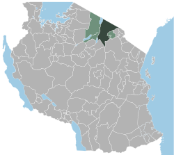
 Location of the Monduli district in Tanzania |
|
| Basic data | |
| Country | Tanzania |
| region | Arusha |
| surface | 6419 km² |
| Residents | 158,929 (2012) |
| density | 25 inhabitants per km² |
| ISO 3166-2 | TZ-01 |
Coordinates: 3 ° 18 ′ S , 36 ° 26 ′ E
Monduli is a district in the Tanzanian region of Arusha with the capital Monduli . It is bordered by the Longido district to the north, the Ngorongoro and Karatu districts to the west, the Manyara region to the south and the Arusha district to the east .
geography
The district is 6,419 square kilometers and has around 160,000 inhabitants (as of 2012). The main rivers in the district are Simba, Kirurumo, Mto wa Mbu, Selela (Kabambe) and Engaruka. Lake Manyara is located on the western border. According to the climatic zones, the district is divided into 3 areas:
- Highlands: The area is characterized by a number of isolated mountains, the Monduli, Lepurko, Loosimingori and the Lengai, with an average altitude of 2000 and a maximum of 2900 meters above sea level. The climate is cool and moderately humid with an average temperature of 20 degrees Celsius and an annual rainfall of 1000 millimeters.
- Hill zone: This zone is characterized by flat hilly plains with a height of 600 to 1200 meters. The climate here is semi-arid with temperatures between 20 and 30 degrees Celsius and 400 to 600 millimeters of annual precipitation.
- East African Rift Plain : This lowland plain is very dry and has high temperatures of 23 to 35 degrees Celsius. On average, there is less than 500 millimeters of rain per year.
history
The name of the district comes from a rich ancestor of the Maasai who was called Monduli. He lived at the end of the 18th century at the time of German colonization. During the British colonial rule, the area was called "Monduli Massai District" and also included the current districts of Kiteto, Simanjiro, Ngorongoro and Longido. In 1979 Kiteto, which at that time still included Simanjiro, was split off, in the 1980s Ngorongoro became a separate district and since the separation from Longido in 2005 the district has its present form.
Administrative division
The district is divided into three districts (divisions) with 20 parishes (wards):
Kisongo
|
Makuyuni
|
Manyara
|
population
| About 40 percent of the population belong to the Maasai ethnic group, who are mainly engaged in cattle breeding. Half as many belong to the Arusha (also called Waarusha).
The literacy rate of those over fifteen rose from 53 percent in 2002 to 61 percent in 2012, for men from 64 to 69 and for women from 44 to 55 percent. Of those over five years old, 54 percent could read and write swahili , one percent only in English and twenty percent swahili and English. |
 |
Facilities and services
education
In 2012, 64 percent of children attended elementary school, which is below the average in the Arusha region, where 80 percent attended elementary school.
health
In the district there was one hospital, one health center and seventeen pharmacies (as of 2003). Six percent of the population had social security (as of 2012).
Economy and Infrastructure
In 2012, 60 percent of those over the age of ten were gainfully employed, 19 percent worked in the household, 16 percent were schoolchildren or students, 2 percent were unemployed and 3 percent unable to work. Fifty percent of households had a radio, nine percent had a television, 63 percent had a mobile phone and three percent had a car.
Agriculture
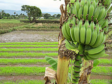
Agriculture is the most important branch of the economy in the district, more than 90 percent of the population live from agriculture and animal husbandry. Around 88,000 hectares of arable land are cultivated. In the southern part of the country there are some large farms, otherwise the agriculture is mostly done by small farmers for self-sufficiency. The main crops are corn, beans and rice, coffee and sunflowers are also grown. The main livestock are goats, cattle and sheep. There is little fishing on Lake Manyara.
traffic
|
 |
Forest
Large parts of the district are bare because too many trees have been felled over decades and entire stretches of forest have been destroyed by fires. Droughts and livestock have also affected the growth of trees. The district operates a reforestation program in which 15 million trees are planted annually (as of 2019). The following forests exist in the Monduli district:
| Surname | size
(Ha) |
administration |
|---|---|---|
| Monduli (Komolonik) | 6059 | administered by central government |
| Lendikinya | 3689 | under district administration |
| Burko | 540 | administered by central government |
| Essimingor | 6100 | administered by central government |
| Lolkisale | 960 | locally managed |
| Selela | 1190 | locally managed |
| Mto wa Mbu | 1738 | locally managed |
| Esilalei | 1324 | locally managed |
| Eluwai | 1422 | locally managed |
Web links
Individual evidence
- ^ Tanzania Regional profiles. Retrieved October 12, 2019 .
- ^ A b c d e Monduli District Council, Investment Opportunities. The United Republic of Tanzania, accessed October 24, 2019 .
- ^ Arusha Regional, District Monduli, Historia. Retrieved October 24, 2019 .
- ^ Monduli District Council, Administration, Administrative Area. The United Republic of Tanzania, accessed October 24, 2019 .
- ^ Tanzania Regional Profiles, 02 Arusha Regional Profiles. (pdf) The United Republic of Tanzania, 2016, pp. 68, 71 , accessed on October 24, 2019 .
- ^ Tanzania Regional Profiles, 02 Arusha Regional Profiles. (pdf) The United Republic of Tanzania, 2016, p. 81 , accessed on October 24, 2019 .
- ^ Report on Basic Findings in Outpatient Facility Evaluations in Arusha Municipality, Arumeru District and Monduli District. (pdf) World Bank, June 10, 2003, p. 6 , accessed October 25, 2019 .
- ^ Tanzania Regional Profiles, 02 Arusha Regional Profiles. (pdf) The United Republic of Tanzania, 2016, p. 124 , accessed on October 24, 2019 .
- ^ Tanzania Regional Profiles, 02 Arusha Regional Profiles. (pdf) The United Republic of Tanzania, 2016, p. 92 , accessed on October 24, 2019 .
- ^ Tanzania Regional Profiles, 02 Arusha Regional Profiles. (pdf) The United Republic of Tanzania, 2016, pp. 121–122 , accessed on October 24, 2019 .
- ^ Tanzania Regional Profiles, 02 Arusha Regional Profiles. (pdf) The United Republic of Tanzania, 2016, p. 130 , accessed on October 25, 2019 .


