Monkey River
| Monkey River | ||
|
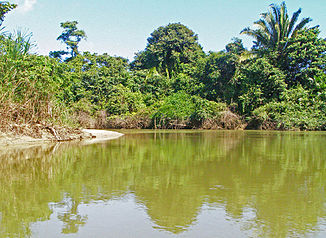
lower part of the Monkey River estuary |
||
| Data | ||
| location | Toledo District , Belize | |
| River system | Monkey River | |
| source | in the Maya Mountains 16 ° 30 ′ 8 ″ N , 88 ° 51 ′ 47 ″ W |
|
| muzzle | in Monkey River Town in the Gulf of Honduras ( Caribbean ) Coordinates: 16 ° 21 ′ 54 " N , 88 ° 29 ′ 3" W 16 ° 21 ′ 54 " N , 88 ° 29 ′ 3" W
|
|
| length | approx. 60 km | |
The Monkey River is a 60 km long river in Belize, Central America .
It rises in the Maya Mountains in the province of Toledo near the border with Guatemala and flows eastwards towards the Caribbean Sea and flows into the Gulf of Honduras at Monkey River Town . The Monkey River is of great importance to the downstream Belize Barrier Reef , as many fish and other living things benefit from the mixed seawater with the clear water of the river.
The Mayan ruins Lubaantun and Nim Li Punit are located near the Monkey River, and on the lower reaches the river flows through Payne's Creek National Park .
Individual evidence
- ↑ - ( Memento of the original from September 30, 2007 in the Internet Archive ) Info: The archive link was inserted automatically and has not yet been checked. Please check the original and archive link according to the instructions and then remove this notice.
