
Monte Brè
| Monte Brè | ||
|---|---|---|
 View of Monte Brè and the village of Brè (right) |
||
| height | 925 m above sea level M. | |
| location | Canton Ticino , Switzerland | |
| Dominance | 1.5 km → Materone | |
| Notch height | 140 m ↓ Brè | |
| Coordinates | 719 890 / 96405 | |
|
||
| Development | 1912 by funicular | |

The Monte Bre ( 925 m above sea level. M. ) is a mountain east of Lugano on the flank of Monte Boglia ( 1516 m above sea level. M. ), of the Como Alps within the larger section of Lugano Prealps heard (after the classification system SOIUSA ) .
It is a popular panoramic mountain with a view of the Bay of Lugano and the Valais and Bernese Alps and is considered to be Lugano's local mountain .
Nature and geography

The area around Monte Brè is mostly wooded with oak, beech, birch and chestnut ; the chestnuts were also used economically until the 1950s. Dam - and wild boar , badger and fox live in the forests . Among the protected plants is the Christmas rose , a elecampane -type ( Inula spiraeifolia ) , endemic.
The mountain is one of the sunniest points in Switzerland . On the southern slope with the Lugano villa districts of Aldesago, Ruvigliana and Cassarate, there is Mediterranean vegetation with pine, cypress, palm, acacia, oleander, olive and pomegranate trees, whose flourishing is made possible by the mild, sunny climate of Ticino, which is also at higher altitudes rarely knows frost in winter.
The pastureland of Alpe Bolla ( 1129 m ) extends to the north on the slopes of Monte Boglia.
Infrastructure
Funicolare Cassarate-Monte Brè
Since 1912, a funicular has been running from Lugano-Cassarate via the Ruvigliana intermediate station up the mountain. Section 1 (Cassarate / Ruvigliana) has a length of 196 m and a maximum gradient of 60%. Section 2 (Ruvigliana / Monte Brè) has a length of 1403 m and a maximum gradient of 47.5%. A branched network of hiking trails of varying degrees of difficulty has been developed around the summit. The staircase descent via the village of Brè and the villa districts on the southern slope of the mountain to Lugano (approx. 2 hours, approx. 600 meters difference in altitude) are classified as easy. This path runs partly parallel to the road (7 km) between Brè and Cassarate, partly it shortens the loops.
The mountain paths to the north to Monte Boglia and on to Sasso Grande ( 1,491 m ) and the Capanna Pairolo mountain hut ( 1,344 m ) are marked as medium and difficult , as is the descent from the village of Brè via a natural history and archaeological trail to Gandria on Lake Lugano.
On the summit there is a lookout tower and a Marienkapelle (new building from 1913 with a statue of the Madonna), the previous building on a plateau about 100 m below the summit was demolished during the construction of the first hotel-restaurant in 1913.
There are other restaurants in addition to this hotel restaurant at the mountain station of the funicular, in the village of Brè and in the hiking area north of Monte Brè; here they have the character of typical grottos , i. H. rustic outdoor restaurants with regional cuisine.
Village of Brè
On the east side of Monte Brè, at an altitude of 800 m, is the Lugano district of Brè with around 300 inhabitants. A bus connects the village of Brè with the center of Lugano.
Architecturally, the village of Brè has retained the typical character of a Ticino village. The lavatoio , the former wash fountain, has also been preserved. In the traditional village center you can find a way of art with works by recognized artists.
The Wilhelm Schmid Museum was once inhabited by the painter of the same name and today contains an important collection of his works. Schmid is considered the only Swiss representative of magical realism .
photos

The village of Brè from Monte Brè
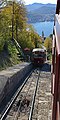
Funicular to Monte Brè

View from Monte Brè to Lugano and Monte San Salvatore


Web links
- Swiss cable car inventory No. 61.007 Cassarate - Monte Brè First section
- Swiss cable car inventory No. 61.008 Cassarate - Monte Brè Second section
- Website of Lugano Monte Brè