Monte Roisetta
| Monte Roisetta | ||
|---|---|---|
|
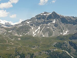
Monte Roisetta from the west, from the Finestra di Cignana |
||
| height | 3334 m slm | |
| location | Aosta Province , Italy | |
| Mountains | Valais Alps | |
| Coordinates | 45 ° 53 '14 " N , 7 ° 40' 52" E | |
|
|
||
| Normal way | From Cheneil in the Valtournanche on the south side | |
The Monte Roisetta ( 3334 m slm ) is the second highest peak after the Grand Tournalin in the chain between Valtournenche and Val d'Ayas that branches off to the south from the main Alpine ridge . The mountain offers a good view of the highest peaks in the Valais Alps , especially on the south side of the Matterhorn . The southern summit ( 3324 m slm ) is relatively easy to reach and is accessible from Cheneil ( 2105 m slm ) with marked hiking trails. The slightly higher main summit is about 400 meters north of the south summit, on which there is a simple summit cross .
Increase opportunities
The most popular ascent for over from the Valtournenche over the south side to the summit. The starting point is usually the parking lot just under 100 meters below Cheneil ( 2105 m slm ), there is no public road to the place itself. From Cheneil you can get to Alp Lezan ( 2684 m slm ) directly, initially on the north side of the stream, later directly on the stream . Alternatively, you can also get to Alp Lezan on a much less steep path in a wide arc that sweeps south-east by first following the path towards Col de Nana . From Alp Lezan it goes in a north-easterly direction through the south-west flank interrupted by several craggy zones to the south summit. Allow about four hours for this ascent. The north summit can be reached from the south summit via a brittle ridge, which does not present any climbing difficulties in the true sense, but has very brittle rock and which can be quite tricky to climb in snow or wet.
Alternatively, Monte Roisetta can also be reached from the Valle d'Ayas via the southeast side. The starting point is Saint Jacques in the municipality of Ayas . From there you can take a marked path to a hollow west of the Palon die Nana . From there you climb in a northerly direction to the saddle between Grand Tournalin and Monte Croce (also Monte Brun , 2894 m slm ). From the saddle you cross the east side of the Gran Tournalin above the small Lago Verde ( 2723 m slm ) and then reach the Monte Roisetta via its not too steep southeast flank. This climb takes about five hours. The Rifugio Grand Tournalin , which is a little off the beaten track, can also be used as a base when climbing this ascent variant .
Another possibility to reach the summit of Monte Roisetta is the north ridge of the Colletto di Roisetta ( 2826 m slm ) located 1300 meters north of the summit . However, climbing difficulties have to be mastered that are rated III- .
In particular, the ascent from the southwest is also suitable as a ski tour .
literature
- Michael Waeber: Valais Alps. Area guides for hikers, mountaineers, ski tourers, climbers. 13th edition, Bergverlag Rudolf Rother, Munich 2003, ISBN 3-7633-2416-X .
Individual evidence
- ↑ a b c d M. Waeber: Valais Alps. Marginal numbers 1121 to 1124, see literature.
- ↑ summitpost.org: Monte Roisetta. Retrieved October 7, 2014.
Web links
- Map section at map.geo.admin.ch
- gulliver.it: Roisetta (Mont), Punta Sud da Cheneil (Italian)


