Montherlant
| Montherlant | ||
|---|---|---|
|
|
||
| local community | Saint-Crépin-Ibouvillers | |
| region | Hauts-de-France | |
| Department | Oise | |
| Arrondissement | Beauvais | |
| Coordinates | 49 ° 17 ' N , 2 ° 3' E | |
| Post Code | 60790 | |
| Former INSEE code | 60417 | |
| Incorporation | January 1, 2015 | |
Montherlant was until 2014 an independent French commune in the department of Oise in the region of Hauts-de-France . With effect from January 1, 2015, it was integrated into the neighboring municipality of Saint-Crépin-Ibouvillers .
geography
The town, which is historically part of the Pays de Thelle and is located west of the A16 autoroute , is around nine kilometers northwest of Méru on the D129 departmental road.
history
From 1826 to 1832, today's neighboring municipality Pouilly formed part of the former municipality.
Attractions
- The Assumption Church from the 15th and 18th centuries, registered as a monument historique in 1970.
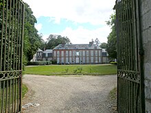
- The Montherlant Castle, once owned by the de Montherlant family, was registered as a monument historique in 2003.
- Ruins of the Château de Pontavesne castle
Personalities
- François Millon de Montherlant (1723–1794), Member of the Estates General from 1789 , executed in 1794.
Web links
Commons : Montherlant (Oise) - Collection of images, videos and audio files
Individual evidence
- ↑ Eglise in the Base Mérimée of the French Ministry of Culture (French)
- ↑ http://clochers.org/Fichiers_HTML/Accueil/Accueil_clochers/60/accueil_60417.htm
- ↑ Château de Montherlant in the Base Mérimée of the French Ministry of Culture (French)

