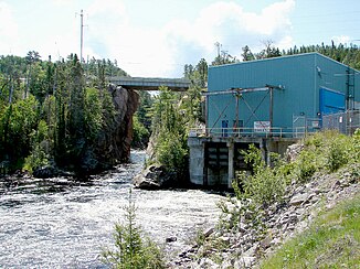
Montreal River (Lake Superior, Ontario)
| Montreal River | ||
|
Mouth of the Montreal River into Lake Superior |
||
| Data | ||
| location | Algoma District , Sudbury District in Ontario, Canada | |
| River system | Saint Lawrence River | |
| Drain over | Saint Marys River → St. Clair River → Detroit River → Niagara River → Saint Lawrence River | |
| origin |
Montreal Lake 47 ° 42 '24 " N , 83 ° 33' 50" W. |
|
| Source height | 447 m | |
| muzzle |
Lake Superior at Montreal River Harbor Coordinates: 47 ° 14 '20 " N , 84 ° 38' 45" W 47 ° 14 '20 " N , 84 ° 38' 45" W. |
|
| Mouth height | 180 m | |
| Height difference | 267 m | |
| Bottom slope | 2.1 ‰ | |
| length | 130 km | |
The Montreal River is a river in the Canadian province of Ontario .
The Montreal River flows through the two districts of Algoma and Sudbury before flowing into Lake Superior .
River course
The river has its origins in Montreal Lake near the Island Lake community in the northwest of the Sudbury District. From there it flows in a south-westerly direction into the Algoma District and reaches the 40 km long reservoir above Montreal Falls as well as the Montreal Falls settlement and its train station on the Algoma Central Railway . The river continues westward, passing Ontario Highway 17 before flowing into Lake Superior at the Montreal River Harbor community .
Hydropower plants
There are 4 hydroelectric plants along the Montreal River, all of which are operated by Brookfield . In the downstream direction these are:
| Surname | completion position |
Power [MW] |
Number of turbines |
hydraul. Potential [m] |
reservoir | operator |
|---|---|---|---|---|---|---|
| MacKay | 1937-1957 | 62 | 3 | 75.3 | n / A | Brookfield |
| Gartshore | 1958 | 23 | 1 | 35 | n / A | Brookfield |
| Hogg | 1965 | 22.4 | 1 | 24 | n / A | Brookfield |
| Andrews | 1938 | 47 | 3 | 57.78 | n / A | Brookfield |
Tributaries
- Little Agawa River (right)
- Sonny Creek (right)
- Jeff Creek (right)
- Rabbit Creek (right)
- Indian River (right)
- Cow River (left)
- Keelow Creek (left)
- Convey Creek (right)
- Tikamaganda River (right)
- Challener River (left)
- Harvie Creek (right)
- Seahorse Creek (right)
- Tempest Creek (left)
- Puswana Creek (left)
- Ebach Creek (left)
- Sample Creek (left)
- Nawahe Creek (right)
Individual evidence
- ↑ Ontario Power Authority ( Memento of the original from January 1, 2012 in the Internet Archive ) Info: The archive link was automatically inserted and has not yet been checked. Please check the original and archive link according to the instructions and then remove this notice.
