Moose River (Passumpsic River)
| Moose River | ||
|
Moose River in Concord, Vermont |
||
| Data | ||
| Water code | US : 1458528 | |
| location | Vermont , USA | |
| River system | Connecticut River | |
| Drain over | Passumpsic River → Connecticut River → Atlantic Ocean | |
| source | The confluence of the West Branch and East Branch of the Moose River 44 ° 38 ′ 2 ″ N , 71 ° 48 ′ 42 ″ W |
|
| Source height | 542 m | |
| muzzle |
Passumpsic River Coordinates: 44 ° 25 ′ 23 " N , 72 ° 0 ′ 40" W 44 ° 25 ′ 23 " N , 72 ° 0 ′ 40" W |
|
| Mouth height | 173 m | |
| Height difference | 369 m | |
| Bottom slope | 7.6 ‰ | |
| length | 48.5 km | |
| Catchment area | 327.6 km² | |
| Left tributaries | Hay Hill Brook , Cold Brook , Stockwell Brook , Stiles Brook | |
| Right tributaries | Dog Brook | |
| Communities | East Haven , Granby , Concord , Victory , St. Johnsbury | |
| Navigable | No | |
The Moose River is a river in Vermont and a left tributary of the Passumpsic River . It is created by the confluence of the East Branch Moose River and the West Branch Moose River at the foot of East Mountain .
course
The river meanders over a distance of 15 km through heavily wooded and hilly terrain in a southerly direction to the confluence of Hay Hill Brook ; here the river turns west and follows a flat valley to its mouth at St. Johnsbury. In the lower part of the course, US Route 2 and the Lunenburg – Maquam railway run parallel to the river.
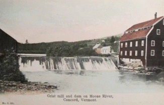
The Moose River and its tributaries are largely unregulated and close to nature, despite their proximity to residential and transport structures. With the exception of a few sections in its middle reaches, it is white water with rapids and cliffs. The water power of the river was used for various mills and sawmills, but also for small factories until around 1900. Plans for the New England Power Company to build a dam to generate electricity in the upper course of the river, which emerged after the Second World War and led to long-lasting debates, were made in 1969 through the purchase of the land in question by the State of Vermont and the establishment of a nature reserve at this point , the Victory Basin Wildlife Management Area . Today the rapids are a magnet for trout anglers and wilderness tourists, especially since the river valley is well developed with roads, campsites and hiking trails.
The water quality of the river is assessed by the competent supervisory authority as very good to excellent along its entire course .
Web links
- Water protection report of the supervisory authority, p 41 ff
- Brief description of the Victory Basin Wildlife Management Area
