Mossblown
| Mossblown | ||
|---|---|---|
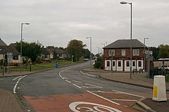
| Street in Mossblown | ||
| Coordinates | 55 ° 30 ′ N , 4 ° 32 ′ W | |
|
|
||
| Residents | 2186 2011 census | |
| administration | ||
| Post town | AYR | |
| ZIP code section | KA6 | |
| prefix | 01292 | |
| Part of the country | Scotland | |
| Council area | South Ayrshire | |
| British Parliament | Central Ayrshire | |
| Scottish Parliament | Carrick, Cumnock and Doon Valley | |
Mossblown is a village in the Scottish council area of South Ayrshire . It is located around ten kilometers northeast of Ayr and twelve kilometers south of Kilmarnock . The River Ayr runs a few hundred meters south . In the course of the 2011 census survey, 2186 inhabitants were counted in Mossblown.
In Auchincruive to the west is the mansion Oswald Hall , which dates back to a tower house of unknown date. The building is classified as a monument in the highest Scottish monument category A. Another category A building, the northern of mossblown Villa Neil Hillhouse .
traffic
The B742 and B743 run through Mossblown. They connect the village to the A77 in the west, the A70 in the south and the A75 in the west. In 1870 the Glasgow and South Western Railway opened the Ayr – Mauchline line . Mossblown owned a train station along the route, which, although located in Mossblown, was named after the neighboring town of Annbank . However, the station has now been closed. With the Glasgow Prestwick Airport is an international airport located about three kilometers to the west.
Individual evidence
- ^ Entry in the Gazetteer for Scotland
- ↑ 2011 census
- ↑ Listed Building - Entry . In: Historic Scotland .
- ↑ Entry on Auchincruive House in Canmore, the database of Historic Environment Scotland (English)
- ↑ Listed Building - Entry . In: Historic Scotland .
- ↑ Information about Mossblown train station

